
This route loops you around the ragged edges of Donegal, from walled city streets to the most northerly headlands and back down to soft surfing beaches. You begin in Derry, where river and history fold together inside old walls, then slip across the border through Muff and out towards Lough Foyle. Greencastle, Malin Head and the shores of Inishowen give you ferries, fishing harbours and big horizons, before you swing back through Buncrana and into the calmer folds of Lough Swilly.
From there the road winds through Ramelton and Rathmullan to Ballymastocker Bay and Fanad Head, where beaches and lighthouse views stack up one after another. Downings and Glenveagh pull you into classic Donegal country, all granite, bog and bare hills. The route then threads through Bunbeg, Dungloe and Rosbeg to the far reaches of Slieve League country at Malin Beg, before turning back through Killybegs and Donegal Town. You finish with Rossnowlagh and Ballyshannon, where long, easy surf beaches and estuary light soften everything back down again.
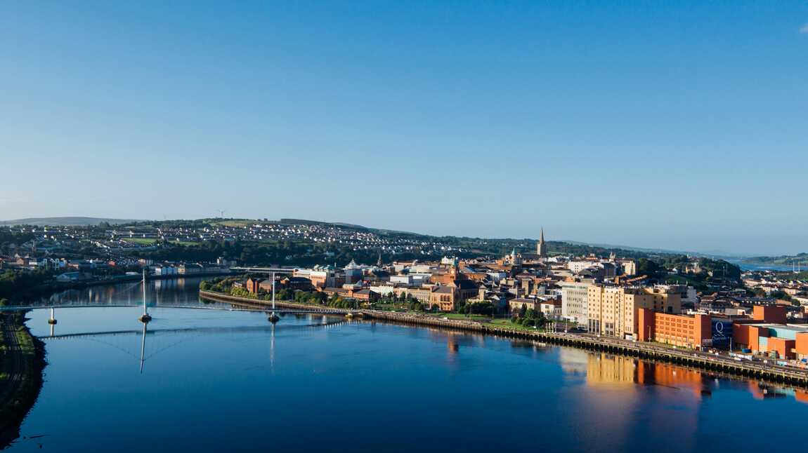
Derry sits wrapped in its seventeenth century walls, a compact city where history and everyday life share the same tight grid of streets. You drive in alongside the River Foyle, cross one of the bridges and feel the place close around you in a way that is comforting rather than cramped. The walls give you a ready made walking route, a raised path that loops above murals, churches, guildhalls and modern shopfronts.
From up there you see the curve of the river, the sprawl of the Bogside and the hills beyond the city edge. It is a place where stories are very present, but so is the sound of students, shoppers and buses, which keeps everything firmly anchored in the present. Derry is a lively beginning, giving you cafés, music and a strong sense of place before the route heads into quieter Donegal roads.
Muff is your first Donegal village, sitting just over the border with Derry on the way towards the Inishowen Peninsula. It is a modest cluster of houses, shops and pubs strung along the main road, with views opening out to low hills and the waters of Lough Foyle not far away. There is a gentle sense of crossing a threshold here, more in road signs and accents than any obvious line.
It is the sort of stop where you might grab fuel, a coffee or a quick pint, and listen in on the rhythms of local conversation. The landscape around is soft rather than dramatic, but the knowledge that wilder ground lies ahead makes it feel like a small prelude, the first Donegal note in what will become a much bigger tune.
Greencastle sits snug on the shore of Lough Foyle, a proper working harbour with ferries and fishing boats busying the water. At Harbour View you look across to Magilligan and the wider mouth of the lough, with the shapes of ships moving slowly in and out. Nets dry on quays, pots are stacked in messy towers and gulls patrol every corner in hope of scraps.
The village rises gently behind the harbour, with houses, shops and a couple of pubs facing the water. You can walk the pier, watch the ferry load and unload, or simply lean on a wall and count the different sorts of vessels going about their business. It feels both practical and quietly scenic, a place where the sea is part of daily life rather than just a backdrop.
Malin Head is the far northern exclamation mark of Ireland, a place where the land narrows to rock and grass before stopping abruptly at the Atlantic. You drive out past scattered houses and fields, then climb to a bare headland where old signal towers and modern masts share the same ground. From the top you can see the coastline curl away in both directions, headlands stepping into the distance under a huge sky.
Down on the lower paths, the cliffs drop sharply into the sea. Waves chew at the base of the rock, sending spray up in sudden gusts. In clear weather the horizon feels endless. In rough conditions it can be properly intimidating. Standing there, buffeted by wind, you are very aware that there is nothing between you and the ice cap but water and weather.
Buncrana stretches along the eastern shore of the Inishowen Peninsula, looking out across Lough Swilly to the Fanad side. The town has a long, sandy beach, a castle framed park and a seafront that invites slow strolling. River, shore and main street all sit close together, which makes it an easy place to explore on foot.
You can walk the shore path, watch the light shift over the lough and then duck back into town for a coffee or a pint. The water here feels gentler than out at Malin Head, more like a broad, sheltered fjord than open sea. Buncrana works as a softer interlude in the route, a reminder that not every coastal town is hanging off a cliff.
Ramelton gathers at a bend in the River Lennon, a town with handsome Georgian buildings looking over the water and quiet streets that hint at a busier past. Old warehouses and quays line the river side, some converted, some still carrying the faded patina of age. The tide shifts the colour and shape of the river, leaving mud banks and reflections at low water.
Away from the riverfront, tree lined streets and stone churches give Ramelton a gentle, lived in charm. It feels like a place that has settled into itself, content to let the busier roads bypass it slightly. For you, it is a calm pause on the way to the beaches and headlands of Lough Swilly’s outer edge.
Rathmullan sits directly on the western shore of Lough Swilly, a small village wrapped around a sweep of sand and backed by low wooded slopes. The beach runs in a long arc, and from the shore you can look across to Buncrana and the hills of Inishowen. Boats shift on their moorings, and on still days the water can look almost like a lake, smooth and reflective.
A pier juts out into the lough, perfect for a short wander and a deliberate pause. The village itself has a quiet, holiday feel, with enough pubs and cafés to keep you comfortable without ever feeling crowded. Rathmullan is one of those places where the sea feels close but not threatening, and the light on the lough can be surprisingly soft.
Ballymastocker Beach, viewed from the road above, is one of the classic Donegal scenes. The strand curves in a long, pale sweep, hemmed in by green hills and the blue of Lough Swilly. From the high lay bys you see the full arc of sand and the way the water changes colour from turquoise shallows to deeper, darker tones.
Down on the beach the world simplifies to sand, water and sky. Waves arrive in neat rows, children dig in the dunes and the slope of the shore is gentle enough that paddling feels easy. It has a wide open but safe feeling, a place where you could happily lose hours just walking from end to end.
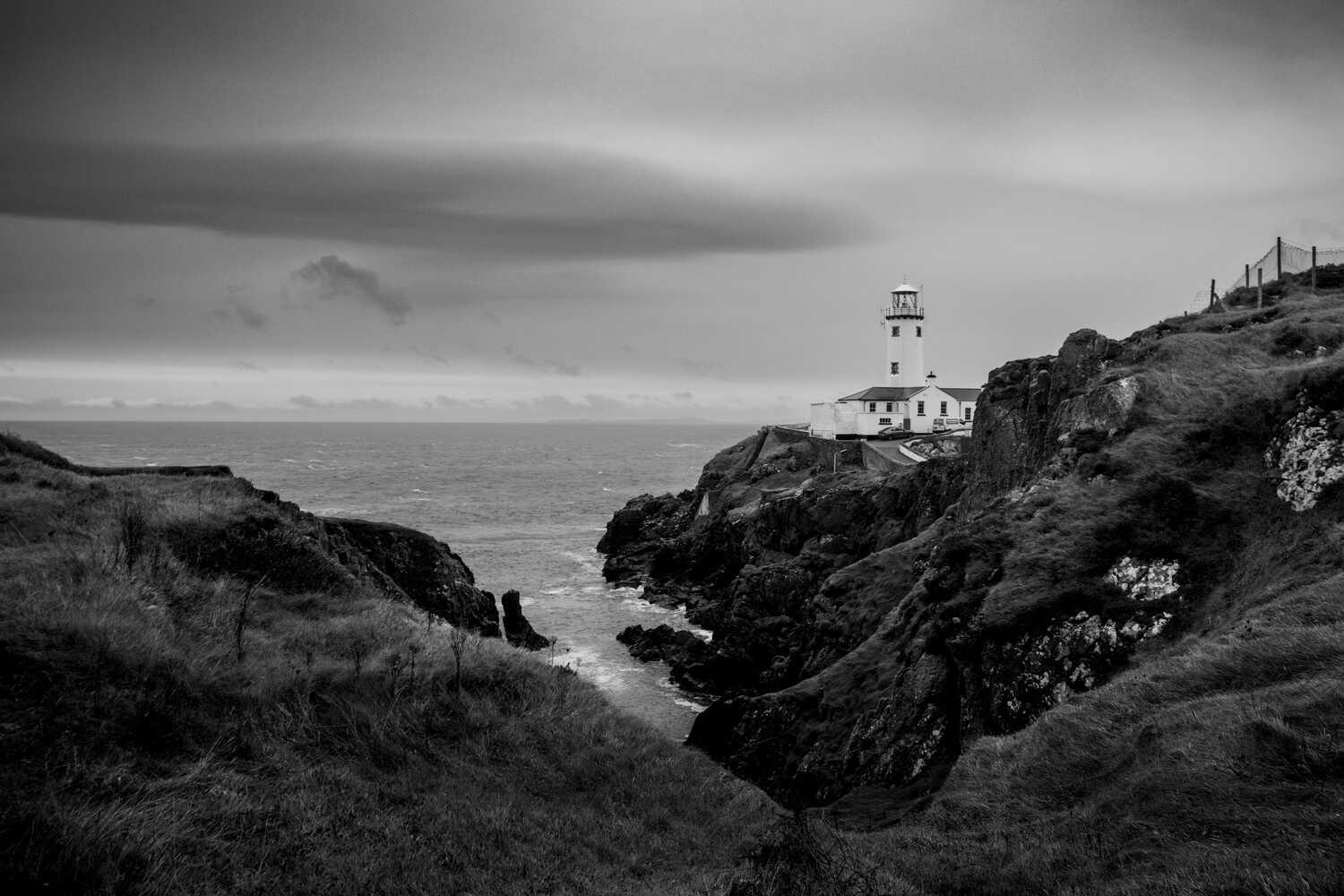
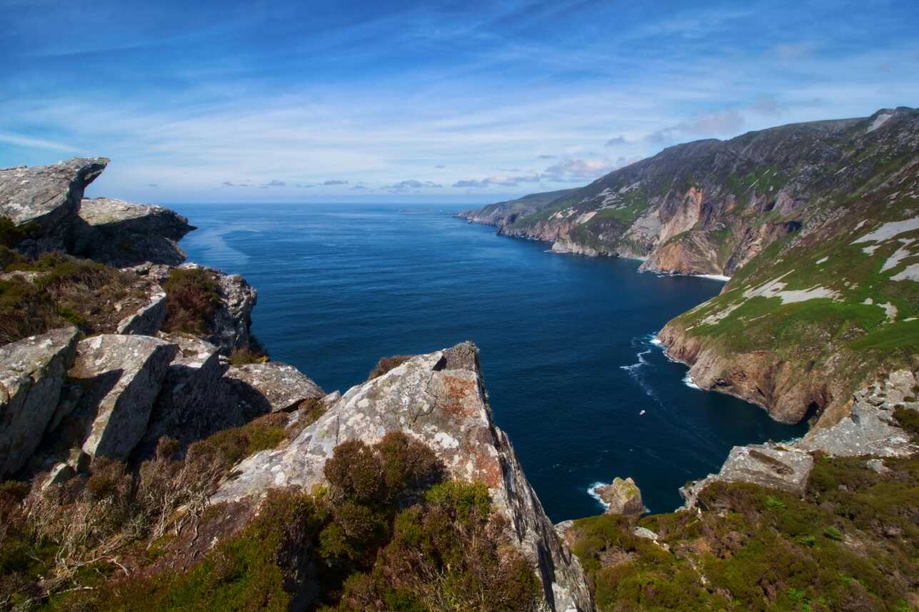
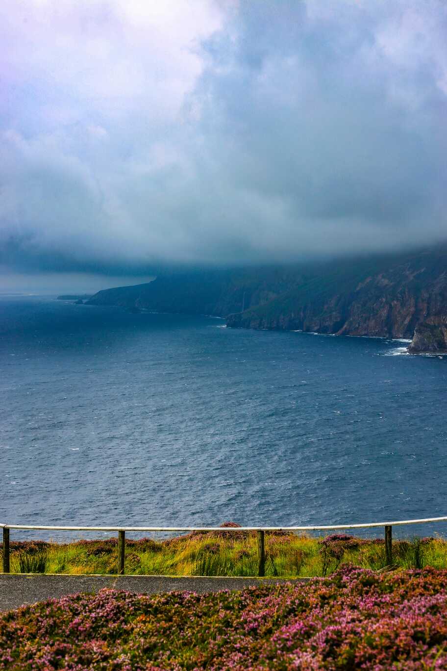
Fanad Head Lighthouse stands on a narrow tongue of rock, white tower and keeper’s cottages crouched above a churning narrows. You approach along a thread of road, the land narrowing until all you can see ahead is lighthouse and sea. Cliffs drop away on both sides, and the Atlantic pushes hard through the gap below, throwing white water against the rocks.
From the paths and viewpoints around the lighthouse you can look back along the ragged coastline of Lough Swilly and out to the wide open north. On calm days, the scene feels crisp and bright. In wilder weather, spray lifts high and the whole headland feels charged. It is one of the defining stops on this route, a clear memory of light, wind and height.
Downings sits on a sheltered bay on the Rosguill Peninsula, its beach curving around calm water with low hills behind. Houses, caravan sites and small hotels gather around the shore, giving the place an easy going, holiday town feel. Fishing boats and leisure craft share the harbour, and the sea here often looks more inviting than intimidating.
From the village, the Atlantic Drive loops out around the peninsula, offering cliff top views, small coves and endless perspectives on headlands and islands. Downings makes a comfortable base for exploring that circuit, with the bonus of being able to walk straight onto the sand at the end of the day.
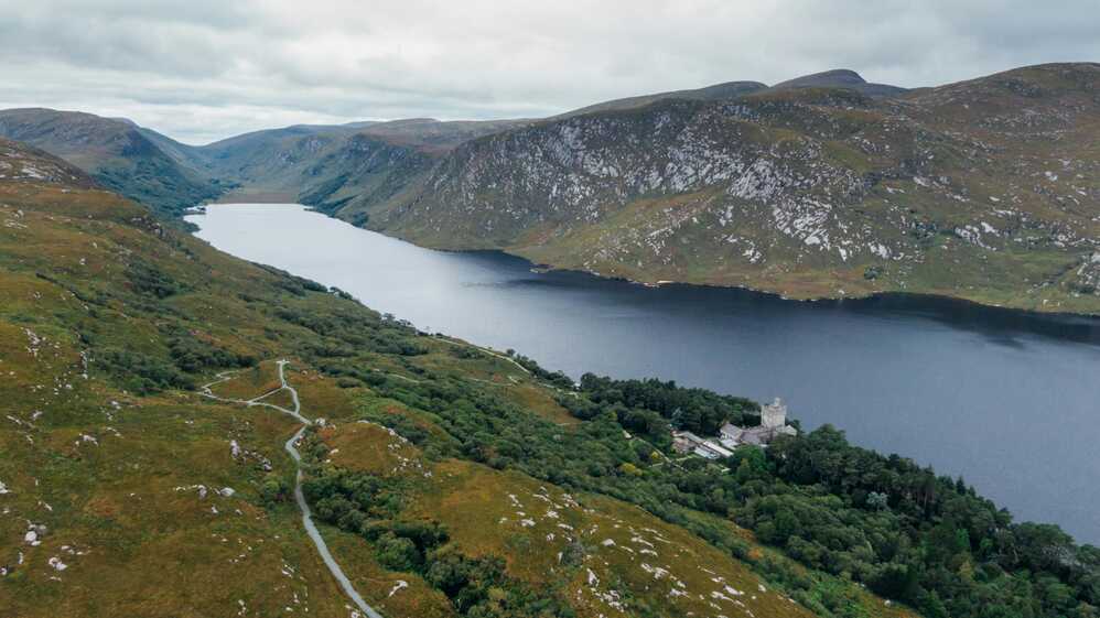
Glenveagh National Park pulls you away from the sea and into a long, glacial valley of lake, heather and steep, rough hillsides. The road in winds between boulders and bog before dropping you near Lough Veagh, where a castle sits in its wooded gardens at the water’s edge. The setting feels almost secret, hidden deep in the Derryveagh Mountains.
Walk the lakeshore paths or climb one of the surrounding slopes and the scale of the landscape becomes clearer. The hills are bare and muscular, the colours muted and subtle, all browns, greens and greys under a wide sky. Glenveagh gives the route a different kind of drama, swapping sea cliffs for mountain silence.
Bunbeg is a small harbour village in the Gaeltacht, where Irish is part of the everyday soundscape and the sea presses right up against the houses. Boats sit in the mud at low tide, resting against their moorings until the water lifts them again. The famous wreck at nearby Magheraclogher Beach leans into the sand, ribs and hull pointing out into the surf like a warning or a monument.
The coastline here is a mix of rock, dunes and scattered islands, with long views across Gweedore Bay. Pubs, shops and small businesses cluster near the harbour, giving the village a practical, unvarnished feel. Bunbeg is a good place to sense the depth of language and tradition in this part of Donegal, with the Atlantic always at your shoulder.
Dungloe gathers around a river and tidal inlet, a modest town that functions as a hub for a wide rural area. The main street runs along a low ridge, lined with shops, pubs and cafés that feel geared to local needs as much as passing travellers. The water curls away in narrow channels, reflecting houses and sky as the tide moves.
In the evenings, lights from the town sit softly on the surface of the inlet, and the whole place feels quietly self contained. Dungloe is less about scenery on your doorstep and more about the knowledge that sea, islands and bogland stretch away in all directions just beyond the houses. It is a good place to restock and reset between more remote stops.
Rosbeg lies at the end of small roads that twist through rough, rocky country to a sheltered harbour and a clutch of houses close to the water. The coastline here is indented with small coves and inlets, each with its own tiny patch of sand or stone. On a calm day the water in the harbour looks almost milky, soft blues and greens blending together.
The land feels like it has been broken into pieces by the sea, with outcrops, islets and headlands scattered in all directions. There is very little noise beyond wind, occasional engines and the constant pulse of waves on rock. Rosbeg has a tucked away, end of the line feel, which is exactly its charm.
Malin Beg Head is home to Silver Strand, one of the most spectacular small beaches in Ireland. From the cliff top car park you look down into a near perfect horseshoe of sand, encircled by steep grassy slopes and rock. A long flight of steps drops to the shore, turning the walk to the beach into a small pilgrimage.
From the sand, the cliffs rise high around you, framing a slice of Atlantic that feels both enclosed and immense. The water is often astonishingly clear, shifting from green to deep blue. On the headland above, the views run out along the coast towards Slieve League and back over the broken edge of this corner of Donegal. Malin Beg is a place where you feel very aware of the power that shaped the land.
Killybegs is a busy fishing port, its harbour crowded with trawlers, cranes and stacked gear. The town runs along the waterfront, with houses, shops and churches rising behind the docks. It smells of salt, diesel and fish, a working mix that underlines how central the sea is to the place.
Walking the quay, you see fishermen mending nets, crews loading supplies and gulls wheeling overhead waiting for anything edible. It is not a polished resort. It is a town that earns its living directly from the water. That gives it a particular energy, especially if you arrive when the fleet is in.
Donegal Town sits at the head of Donegal Bay, clustered around a small harbour and watched over by its castle. The Diamond, the central square, fans out into a web of streets lined with pubs, shops and cafés, creating an easy, compact centre to wander. The castle stands just off the square, its stone walls and tower house adding a clean, strong silhouette to the townscape.
Down by the quay, boats rock gently at their moorings and the bay stretches away towards more distant headlands. The mix of tourist shops and everyday businesses gives the place a steady hum without tipping into pure souvenir territory. Donegal Town feels like a natural anchor on this route, connecting the wild coasts to a sense of history and community.
Rossnowlagh Beach runs in a long, straight strip of sand that seems to go on forever. The dunes behind are low and tufted, and the sea rolls in with broad, easy waves that surfers and swimmers share through most of the year. On bright days the shallows shine with a silvery sheen, reflecting sky and clouds so that the line between land and water blurs.
Cars often park right on the sand when the tide allows, giving the place a relaxed, family beach feel. Yet step away from the busier section and you quickly find quiet stretches where it is just you, the Atlantic and a few distant figures. Rossnowlagh is a soft contrast to the cliffs and headlands earlier in the route, generous and uncomplicated.
Ballyshannon sits above the Erne estuary, one of Ireland’s oldest towns sitting on a series of slopes and bridges that step down to the water. Streets twist and layer over each other, giving small glimpses of the river and the distant sand dunes of Donegal Bay. Old stone buildings and newer fronts sit side by side, all carried by a steady flow of local life.
The river itself is broad and strong here, funnelling towards the sea under bridges and past wooded banks. Standing on one of the viewpoints, you can see how the town has grown with the water, using it as both route and resource. Ending here feels fitting. You finish not quite at the open ocean, but at a place where river and sea shake hands and the whole journey you have made along coasts and headlands seems to collect and settle.
This route feels like a full tour of Donegal’s personality. You start in Derry inside solid city walls with river views and a lively music scene, then slip into Donegal through Muff and the working harbour at Greencastle. Malin Head gives you the far-north drama, all wind, rock and open Atlantic, while Buncrana, Ramelton and Rathmullan soften the mood along the calmer waters of Lough Swilly.
From Ballymastocker’s perfect curve of sand and the white tower of Fanad Head Lighthouse, you swing out to Downings and then inland to Glenveagh, where mountains and a long dark lake trade places with cliffs and surf. The coast around Bunbeg, Dungloe, Rosbeg and Malin Beg turns the volume back up with wrecks, inlets and steep, green-sided coves. Killybegs adds big working harbour energy before Donegal Town, Rossnowlagh and Ballyshannon ease you down gently with long beaches, estuary light and small town streets built around water. It is a loop of headlands, harbours and high ground that always keeps the Atlantic in sight.
In Derry, walk the full circuit of the city walls to get your bearings and views over the Foyle, murals and rooftops in one simple loop. Drop into a café or pub in the centre before you cross into Donegal through Muff. At Greencastle, wander the harbour, watch the ferry work the mouth of Lough Foyle and follow the shore for a closer look at nets, pots and the everyday life of a fishing village.
Malin Head deserves unhurried time. Walk out to the signal tower, follow the paths along the cliffs and watch the Atlantic hammer the rocks below. Back on Lough Swilly, use Buncrana as a base for beach walks and a stroll through the castle grounds, then step into slower riverfront wandering in Ramelton and along the long strand at Rathmullan. Pull in at the high viewpoints above Ballymastocker Beach to really see the sweep of the bay before heading out to Fanad Head for lighthouse views and cliff side paths.
Further west, take the Atlantic Drive from Downings as a slow circuit of coves and lookouts. In Glenveagh National Park, either walk the lakeside path to the castle or climb one of the surrounding hills for a bigger view. Around Bunbeg and Dungloe, explore beaches and small harbours, and, if the tide is right, visit the wreck at Magheraclogher. At Rosbeg and Malin Beg, walk down to the tiny coves and Silver Strand, even if you only stay long enough to feel how steeply the cliffs rise around you. Finish the route with a harbour and castle wander in Donegal Town, then long, easy walks along Rossnowlagh Beach and short estuary viewpoints around Ballyshannon.
Derry gives you a strong opening, with plenty of pubs, cafés and restaurants packed inside and around the walls, so it is worth planning a night there. Once you cross into Donegal, Muff and Greencastle offer straightforward village pubs and chippies that work well for casual lunches or early dinners, often with fresh fish on the menu.
Buncrana and Ramelton both have good options for coffee and food, with Buncrana leaning more towards seafront cafés and takeaways, and Ramelton offering quieter, riverside places. Rathmullan is ideal for a simple meal by the lough, and Downings gives you another little cluster of bars, cafés and hotel restaurants geared to beachgoers and people driving the Atlantic Drive.
Letterkenny (just off your line between Fanad and Glenveagh) can act as a backup food hub if you need more choice. Out towards Bunbeg, Dungloe and Rosbeg, you rely more on local pubs and hotel bars, which can be excellent but seasonal, so it is sensible to keep your timings flexible. Killybegs is very much the spot for seafood straight off the boats, while Donegal Town has the widest range on the southern side of the loop, from casual cafés to busy restaurants around the square and harbour. Rossnowlagh and Ballyshannon finish things off with beach cafés, hotel dining rooms and traditional pubs that suit a last-night meal and a quiet drink.
You can break this route into a few strong bases. Derry makes sense as a starting point, with everything from hostels to comfortable hotels within walking distance of the walls, pubs and river. On Inishowen, you could base yourself near Malin Head, Buncrana or around Greencastle, depending on whether you prefer exposed headland, lough views or harbour life.
Around Lough Swilly, Rathmullan and the hills above Ballymastocker offer small hotels, guesthouses and B and Bs with views down to the water. Downings then gives you a beachy option, with holiday parks, small hotels and self catering places close to the sand. If you want a quieter, inland break in the middle of the route, look for stays near Glenveagh or in Letterkenny for easier access to the park.
Further west, Bunbeg and Dungloe both work as low key bases for exploring the island dotted coastline, with small inns, guesthouses and Gaeltacht B and Bs. Rosbeg and the Malin Beg area suit those who like really remote nights in tiny settlements close to the cliffs and coves. Towards the end of the loop, Killybegs has harbour front hotels and guesthouses, while Donegal Town offers a full spread of accommodation and feels like the natural hub before you roll out to Rossnowlagh and on to Ballyshannon. If you prefer to keep packing to a minimum, using Derry, Downings and Donegal Town as your three main bases will still let you explore almost all of this route in relaxed day trips.
TopStops is built to be used like a shared guidebook, not a strict itinerary.
Browse the routes to see how others have travelled an area, check the map for regularly recommended stops, and get a feel for the journey with photos, highlights, and quick info on each place. When you’re ready, follow the route yourself or adapt it to your own trip.
If you discover a spot we’ve missed, submit it. The best community suggestions get added to the map, so every route slowly improves with real travellers’ input.
Do you know somewhere we should feature in our route? Message us and we’ll get it added.

