
This route hugs the far southwest like you’re tracing the ragged edge of the map with your finger. You begin at Land’s End, where the country simply runs out and the Atlantic takes over, then work your way along a coast shaped by storms, tin and stories. Pendeen and St Ives give you that classic West Cornwall mix of moorland, mine stacks and bright, painterly bays. From there, wide beaches and surf towns string together like beads: Perranporth, Newquay, Padstow and Polzeath each adding their own version of sand, swell and sea air, from scruffy, wave-chasing energy to harbourside fish-and-chips and estuary calm.
Further north, the mood turns a touch wilder and more mythic. Tintagel throws you out onto a headland of ruined walls and Arthurian whispers, while Hartland Point and the North Devon coast remind you just how hard the Atlantic can hit, cliffs braced against huge, slow waves. You finish in Croyde, where dunes, headlands and a clean beach offer a softer place to land after so much raw coastline. It’s a route of short hops and big horizons, where almost every stop gives you a new way to watch the sea and a different reason to pull over, linger a little longer and promise yourself you’ll come back.
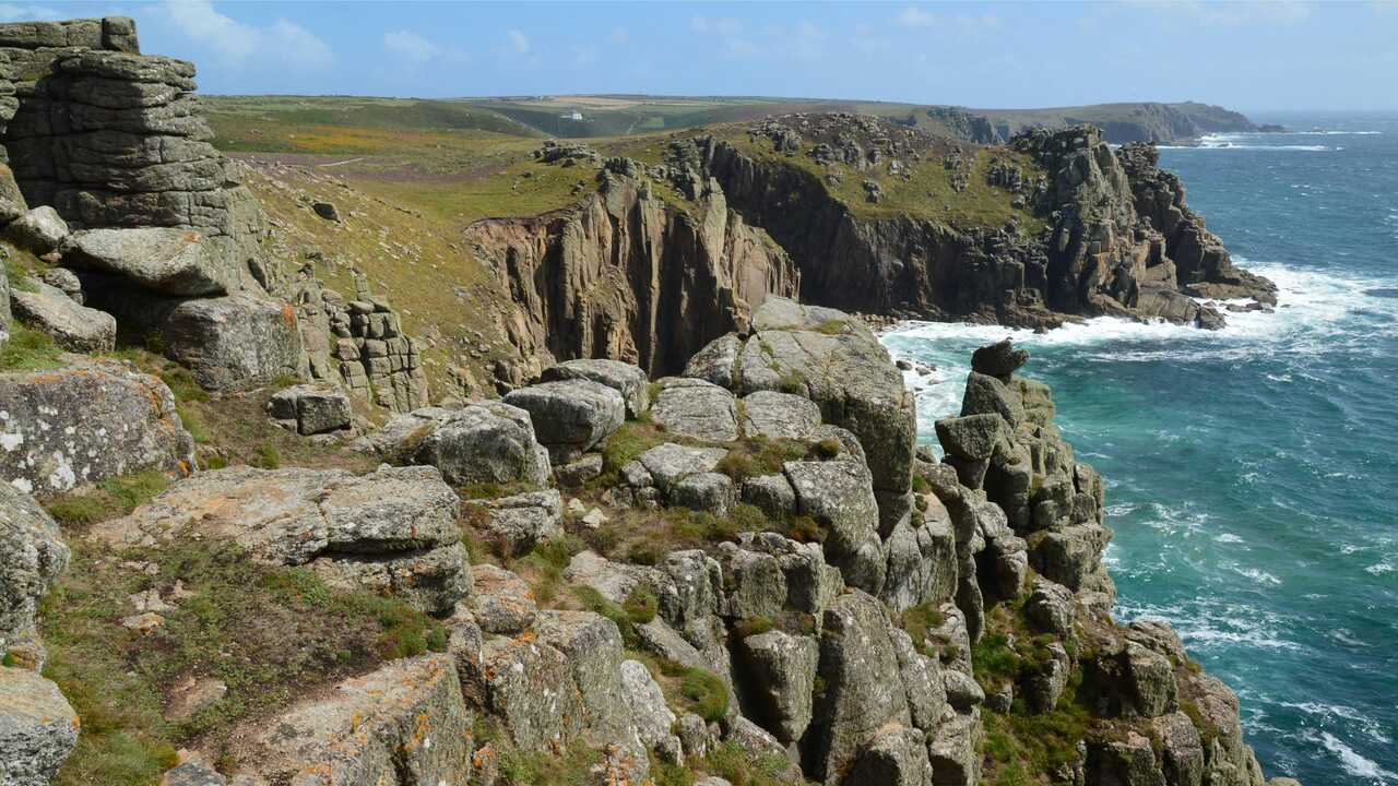
Standing at Land’s End, you feel like you’ve walked to the edge of the page. The coastal path curls along ragged cliffs, waves smashing white against dark rock far below, and the wind comes at you straight off the Atlantic with nothing to slow it down. Gorse and heather cling to the cliff tops, and seabirds ride the updrafts as if they’ve been doing it since before there were names for this place. You step towards the viewpoints and suddenly the sea is all there is a shifting sheet of blue and green reaching out to the horizon.
Yes, there’s the familiar signpost and a bit of tourist bustle behind you, but you can turn your back on that easily enough and follow the path towards quieter coves and headlands. Out here you’re walking in the footsteps of tin miners, lighthouse keepers and countless travellers who came simply to see where the land stops. It feels like both a beginning and an ending, which is exactly the right mood for this route.
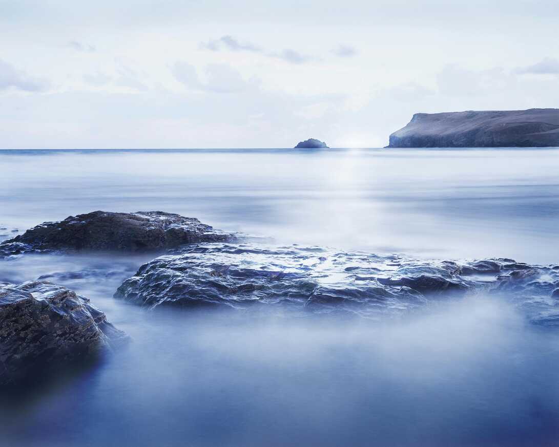
By the time you reach Pendeen, the landscape has tightened into something wilder. The Old Vicarage sits tucked inland from the cliffs, surrounded by stone walls, hedgerows and the faint echo of chapel bells. Old mine stacks stand on the horizon like blunt fingers, reminders of when this coast hummed with tin and the nights were lit by engine houses and the glow of smelters. Now it’s quieter: the soundscape is mostly wind in the trees, rooks in the fields and the distant low rumble of the sea.
From here, lanes lead you out to some of West Cornwall’s starkest, most beautiful coastline. You can park and walk to Pendeen Watch, where the lighthouse keeps its steady vigil over jagged rocks, waves piling in from the Atlantic in long, heavy sets. Coming back to a place like the Old Vicarage after a cliff-top walk feels right – a sense of shelter and history, of thick walls that have seen storms before, and of being properly rooted in this far edge of the country.
St Ives Bay opens out in a sweep of sand and light that can feel almost unreal on a clear day. You crest the hill and there it is: pale beaches curving around turquoise water, the town huddled on its headland with whitewashed cottages and slate roofs tumbling down to the harbour. Artists have been chasing the light here for over a century, and you can see why, it bounces off the sea, slides along wet sand and turns even the simplest scene into something worth staring at.
You wander narrow streets that twist between galleries, pasties shops and tiny courtyards where washing lines criss-cross overhead. Down at the harbour, boats sit on the sand at low tide, children dig moats around castles, and the smell of chips and salt hangs in the air. Walk a little way along the coastal path and the crowds thin, leaving you with wide views across the bay to Godrevy lighthouse. It’s lively, yes, but underneath the bustle is that easy seaside rhythm that makes you want to stay “just one more night”.
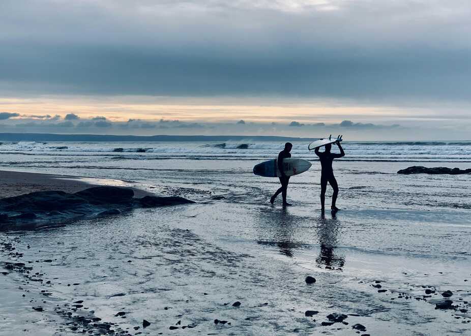
Perranporth greets you with big sky and bigger sand. The village backs straight onto a huge beach where the tide seems to retreat forever, leaving firm, flat sand patterned with pools and ripples. You park up, crest the dunes and suddenly the space opens in front of you. Surfers dotted out in the waves, dogs tearing joyful loops, paragliders sometimes hanging like bright seeds on the breeze.
There’s a salty, slightly scruffy charm to Perranporth. The bar on the beach, the rockpools, the steady stream of people heading down with boards under their arms or buckets and spades in hand it all feels relaxed and unfussy. Follow the coastal path up onto the cliffs and you get that classic north Cornwall mix of golden beach, green headlands and the Atlantic throwing itself against the rocks. On this route, it’s the sort of place where you can rinse the miles out of your legs with a barefoot walk and a pint as the sun drops behind the waves.
Newquay has grown up around its beaches and the energy of the Atlantic. You roll in past surf shops and cafés, feeling the town hum with a mix of locals, families and wave-chasers from all over. Fistral, Towan, Great Western, Lusty Glaze, the names alone sound like a promise of swell and sunsets. From the clifftops, you look down on neat rows of waves marching into the bays, bright boards flickering in and out of the whitewater.
Walk the streets and you catch snatches of music, the smell of sunscreen and takeaway pizza, sand still clinging to ankles and hair. Once a traditional holiday resort, Newquay has morphed into a surf town with all the scruffy, breezy, youthful feel that brings. It’s not subtle, but that’s exactly its appeal. As a stop on your route, it gives you a hit of energy, somewhere to grab a lesson, watch a contest, or just sit on a headland with a coffee, letting the roar of the sea drown out whatever your brain was busy with before.
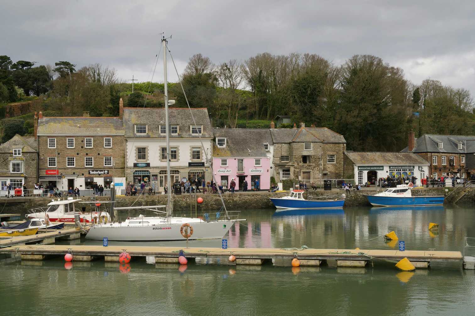
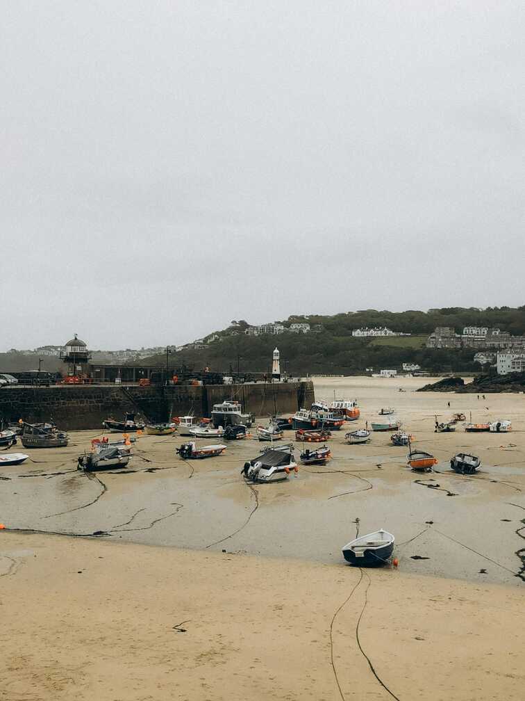
Padstow curls around the Camel Estuary like it’s hugging the water. You arrive to a harbour packed with fishing boats and pleasure craft, quayside walls dotted with people licking ice creams and queuing for fish and chips that really are worth the wait. The tide runs in and out with purpose here, leaving gleaming mudflats and moored boats resting on their sides like tired animals.
Behind the harbour, narrow streets twist up the hill, lined with old stone cottages, smart restaurants and little shops that always seem to have something tempting in the window. This has long been a working fishing port, and that heritage still sits just under the surface, even as Padstow has become a bit of a foodie hotspot. Take the ferry across to Rock or follow the Camel Trail out along the estuary and you’ll see wading birds probing the shallows and wide views opening towards the sea. It’s an easy place to linger into the evening, watching the harbour lights flicker on one by one.
Polzeath feels like a beach that’s built for long days and sandy feet. You crest the hill and see a broad, shallow bay where the waves roll in gently over firm sand, ideal for learners and long-boarders. The village tucks in at the back of the beach, with cafés, surf schools and holiday homes stacked up the slopes, all angled to catch as much of the view as possible.
Park on the edge of the sand when the tide’s out and you’re barely a few steps from being in the water. Even if you’re not surfing, it’s a great place just to walk, paddle and watch the lines of swell peel across the bay. Rock pools dot the edges, headlands frame the horizon, and sunsets often feel like slow, blazing performances played out just for this one curve of sand. Polzeath has a relaxed, easy-going vibe, somewhere that invites you to ditch the schedule, stay for an extra swim, and let the day stretch with the tide.
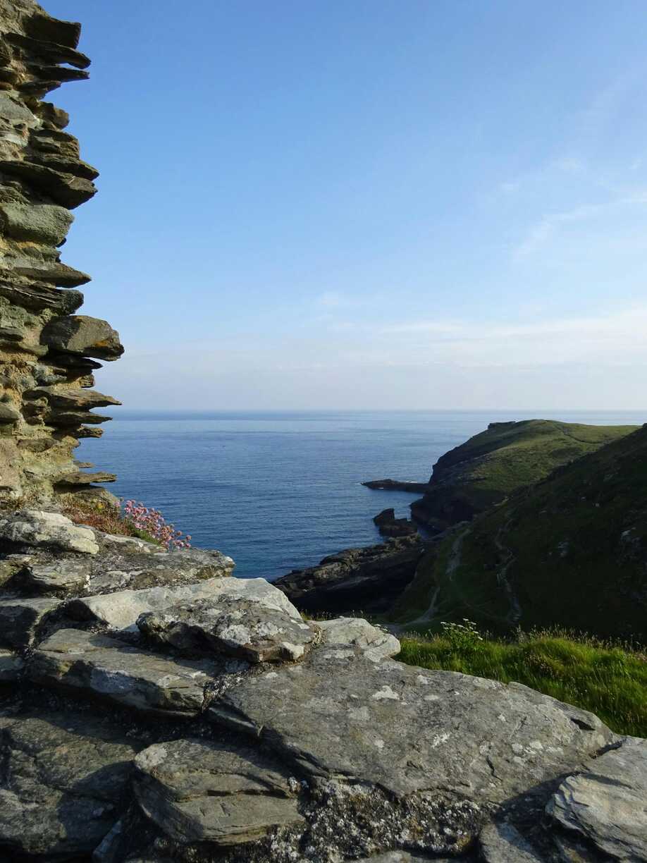
Tintagel carries its stories right on its sleeve. You arrive through a village full of references to Arthurian legend. Banners, shop names, snippets of myth and then follow the path out towards the cliffs where things suddenly feel far more serious. The castle ruins sit scattered across a rocky headland and a tidal island, linked now by a dramatic footbridge that hangs between two sheer drops, the sea crashing hundreds of feet below.
Climb the steps and you’re rewarded with views that make the legends feel almost plausible: jagged cliffs, hidden coves, the constant thunder of the Atlantic punching into the rock. The ruins themselves are a mix of medieval fortifications and older, deeper history, with traces of a Dark Age settlement that once looked out over busy sea routes. Whether you’re here for the myths or the geology, it’s hard not to be moved by the drama of it all. Tintagel is where your route brushes up against the more mythical edge of Cornwall, sea spray and story tangled together on the wind.
Hartland Point feels wild even before you reach the car park. The lanes narrow, hedges grow tall and ragged, and then the land simply stops, dropping abruptly into sheer cliffs where the Atlantic throws itself against the rock in endless, heavy waves. The lighthouse stands pale and solid at the very edge, watching over one of the trickiest stretches of coastline in the southwest.
From the headland, you look down on jagged ribs of rock thrust out into the sea, layers tilted and twisted by long-ago forces. On rough days, the wind can make you brace your feet just to stay steady; on calmer ones, you can hear the deep, rhythmic boom of water hammering into caves below. Shipwrecks, storm legends and the long history of coastal trade hang around this place like sea mist. It’s a raw, elemental stop. One that reminds you how powerful this ocean is, and how thin the line of tarmac you’ve been following really is against it.
Croyde is all about the curve of its bay and the waves that roll into it. You drop into the village past stone cottages and pubs with low beams, then follow the road to where the sand arcs between two green headlands. The beach is wide and golden, backed by dunes and fields, and on a good day the line-up is full of surfers waiting for sets, boards bobbing in the sunlight.
The village itself has a cosy, slightly surf-shack feel - cafés, gear shops, beer gardens where sandy-footed people drift in after a session. Footpaths lead out over the surrounding headlands, giving you big views back over the bay, Lundy Island sometimes a smudge on the horizon. As the light drops, Croyde often feels wrapped in a soft glow, the last of the sun catching breaking waves and the tops of the dunes. It’s a gentle but satisfying final stop on your route: somewhere you can wash salt from your hair, warm up with good food and let the sound of the sea carry you into the evening.
This route connects the more exposed, Atlantic-facing side of Cornwall and North Devon – from Land’s End and the mining coast around Pendeen and St Ives Bay, through Perranporth, Newquay, Padstow and Polzeath to Tintagel, Hartland Point and Croyde. It’s beaches, cliffs and surf towns almost the whole way, with plenty of reasons to just stop and watch the weather roll in.
From Land’s End you can immediately pick up the South West Coast Path towards Sennen or back round to Porthcurno if you’re linking routes. Around St Ives Bay, beaches, the harbour, and Tate St Ives can easily take a day. Perranporth and Newquay are surf-centric, with Fistral the obvious flag for lessons or board hire. North of the Camel estuary the route threads Padstow, Rock and Polzeath – estuary walks, ferries and more surfing. Tintagel Castle adds a chunk of Arthurian myth, and the final leg into Hartland and on to Croyde gives you heavy folded cliffs, steep coast-path sections and then the long surf beaches of Saunton and Croyde.
Between St Just and St Ives, somewhere like The Gurnard’s Head gives you serious cooking in the middle of nowhere. In Newquay, The Fish House at Fistral is the go-to seafood option right above the beach. Padstow is stacked with restaurants and takeaways; Prawn on the Lawn is a good small-plates seafood choice without leaning too hard into celebrity-chef hype. Up in North Devon, Braunton and Croyde are full of decent post-surf cafés and restaurants, and Barnstaple works as a general resupply and dinner hub.
For camping, you can basically hop from cliff to cliff: Trevedra Farm near Sennen, Trevaylor near Pendeen, Ayr Holiday Park above St Ives, Perran Sands above the dunes, Hendra on the edge of Newquay, Padstow Touring Park and Valley Caravan Park at Polzeath. Trewethett Farm CAMC between Tintagel and Boscastle covers the mid-section, with Stoke Barton near Hartland and Ruda Holiday Park at Croyde finishing things off. For hotels, The Land’s End Hotel, St Ives Harbour Hotel, The Headland in Newquay and St Enodoc at Rock form a pretty clean chain of “treat nights” along the route.
TopStops is built to be used like a shared guidebook, not a strict itinerary.
Browse the routes to see how others have travelled an area, check the map for regularly recommended stops, and get a feel for the journey with photos, highlights, and quick info on each place. When you’re ready, follow the route yourself or adapt it to your own trip.
If you discover a spot we’ve missed, submit it. The best community suggestions get added to the map, so every route slowly improves with real travellers’ input.
Do you know somewhere we should feature in our route? Message us and we’ll get it added.

