
This route feels less like a line on a map and more like a story you step into. You start among the bridges and harbours of the west coast, wind your way over high passes and along sea-lochs, then trace the broken edge of the Highlands all the way to the top of mainland Britain before crossing the water to Orkney. The further you go, the bigger the skies become, the smaller the villages, and the more you feel that pleasant sense of being a long way from everything you know. It’s single-track roads and lay-bys with ridiculous views, peat smoke on the air, deer in the heather and that constant glint of water somewhere ahead.
It’s also a very practical adventure. You’ll find just enough shops, fuel stops and pubs to keep you comfortable, but not so many that the wildness is dulled. Some days might just be short hops between nearby bays; others are long, drifting drives where the miles unroll under shifting weather. By the time you’re standing among Neolithic stones on Orkney, you’ll have crossed mountain passes, sandy straths and cliff-fringed coasts – a whole slice of Scotland stitched together into one continuous journey.
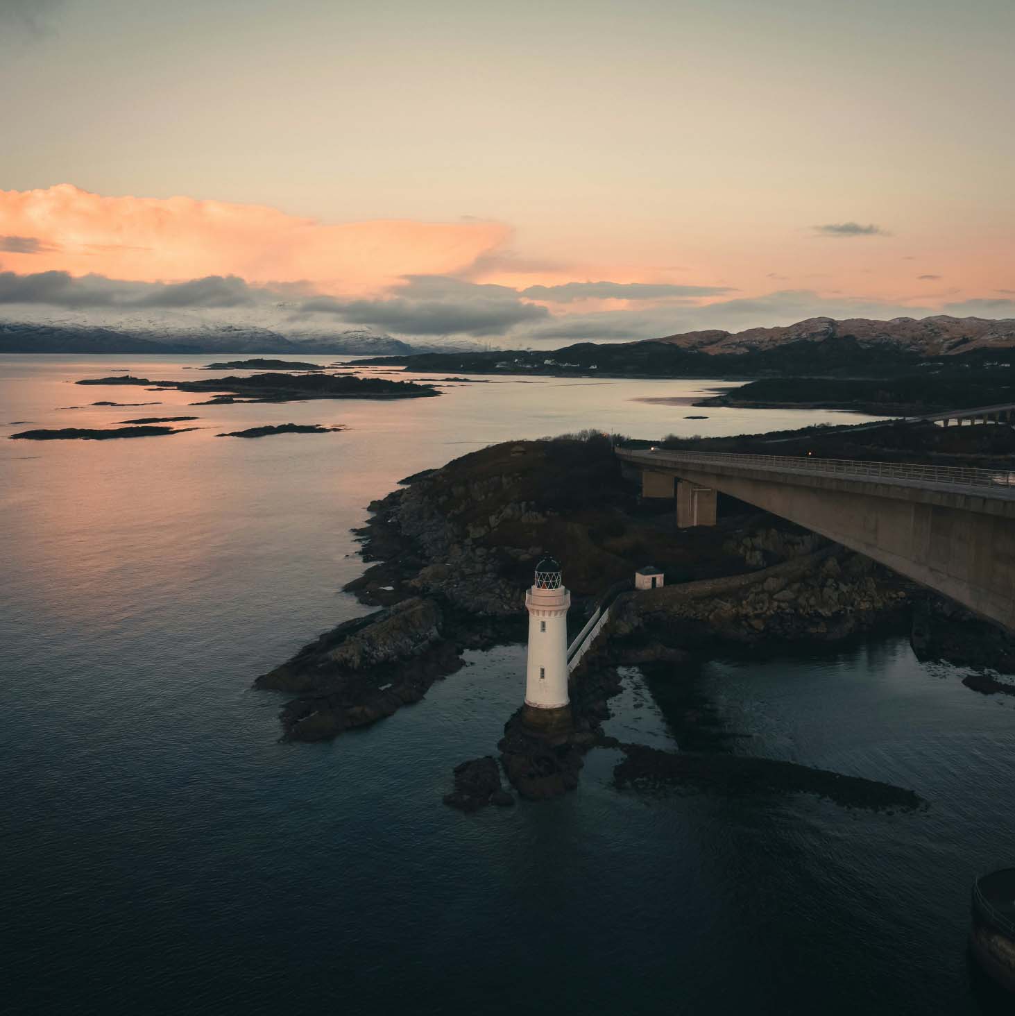
You roll into Kyle of Lochalsh with the feeling that you’ve reached a frontier. The village huddles around the water, fishing boats rocking gently, and the Skye Bridge sweeping away to the left like an invitation. You can hear the clang of masts, the soft thrum of the trains arriving from Inverness, and smell salt and diesel on the air. This is where road, rail and sea knot together, and you feel the journey properly begin.
Take a slow wander along the harbour and watch the light move over the Cuillin ridge across the water. Kyle has always been a crossing place from cattle drovers and steamers to today’s campervans and island buses and you’re just the latest traveller pausing here before pushing on. Stock up on supplies, grab something hot, and stand for a moment with the gulls wheeling overhead. Ahead is the wild north; behind, the rest of the world.
Applecross feels like a prize you earn rather than a dot on a map. Whether you’ve taken the famous Bealach na Bà, curling up through the clouds on hairpin bends, or slipped in along the coastal road, you arrive with your shoulders a little looser and your senses wide awake. The village itself is a soft scattering of white cottages, a strip of sand and a view across to Skye that changes by the minute.
You can hear the hush of the tide on the pebbles and the low murmur from the inn as walkers, bikers and locals trade stories over pints. This peninsula was once one of the most isolated places on the mainland, a world of crofts and small boats. You still feel that remoteness in the wide skies and empty single-track roads, with deer on the verges and eagles somewhere above. It’s the sort of place where you’ll promise yourself “just one night” and then quietly add another.
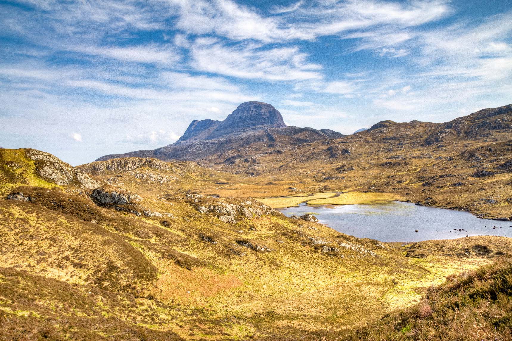
By the time you reach Lochinver, it feels as if the mountains have stepped closer to the road. The village hugs the shore of a sea loch, fishing boats nested together and the scent of smoke, salt and fish in the air. Behind the houses, the Assynt hills rise in strange shapes - Suilven, Canisp, Quinag - like ancient beasts sleeping under a thin green blanket.
You wander the harbour and watch the light slide across the water, fishing gear stacked in quiet piles, dogs trotting along the pier as if they own it. This has always been a working place, tied to the sea and the land, but it’s also a little haven for travellers on the long haul north. You might grab a proper plate of food, hunt down a famous pie, or just sit with a takeaway coffee and listen to the gulls. Stay long enough and you start to feel the slow rhythm of a village that lives by tides and weather, not by clocks.
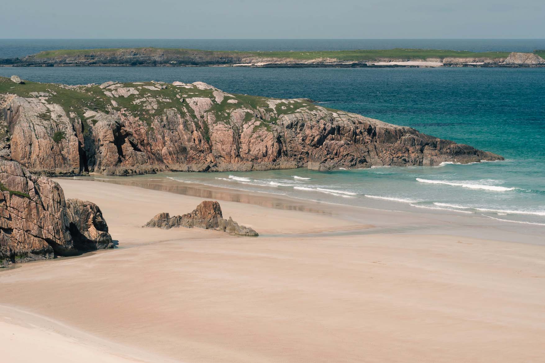
Durness feels like the edge of something. The road finally drops you at a scattering of houses, a tiny shop or two and, beyond them, beaches that look almost unreal. At Sango Bay the waves roll in turquoise and white, crashing against black rocks while the wind tugs at your hood and fills your lungs with cold Atlantic air. On a good day the sand is bright and soft; on a stormy one the whole bay roars.
You walk the cliff paths and peer down into the famous Smoo Cave, a vast mouth in the limestone where legends cling to the dripping walls. Vikings, smugglers, hidden spirits people have been whispering stories about this coastline for centuries, and you can understand why when the light slants low and the sea mist creeps in. Up here, you’re closer to the Arctic Circle than to London, and the nights can feel enormous. Yet there’s always a warm doorway, a cosy bar, or a campsite view that makes you glad you kept driving this far.
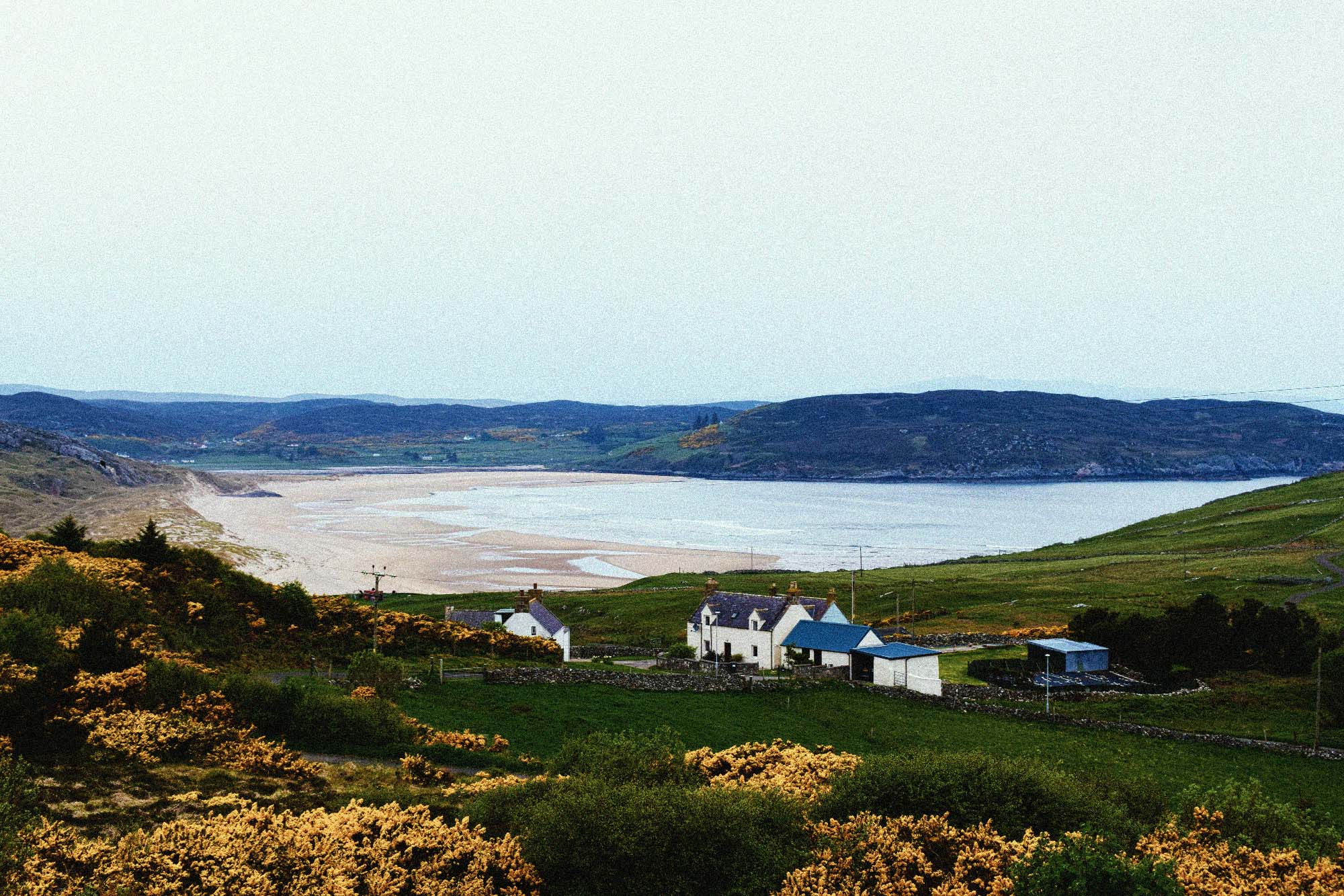
Bettyhill arrives suddenly after a run of big skies and empty bends, perched above the mouth of the River Naver. You crest the hill and there it is: a small cluster of houses, a church, and below them a sweep of golden sand curling round a bay that could easily belong somewhere far further south. The river snakes into the sea, and on a still evening the surface mirrors the shifting clouds like brushed metal.
You might wander down to Farr Beach, the dunes muffling the sound of your steps as you cross. The wind carries the smell of marram grass and salt, and you can hear the distant splash of waves well before you see them. This coast has seen Pictish stones raised, clans feuding, and later the sorrow of the Clearances as people were pushed from their homes. Now it’s peaceful, almost dreamlike, with the odd fisherman or dog walker sharing the view. It’s a gentle pause on your route, a place to breathe, skim a stone, and feel how much land you’ve already crossed.
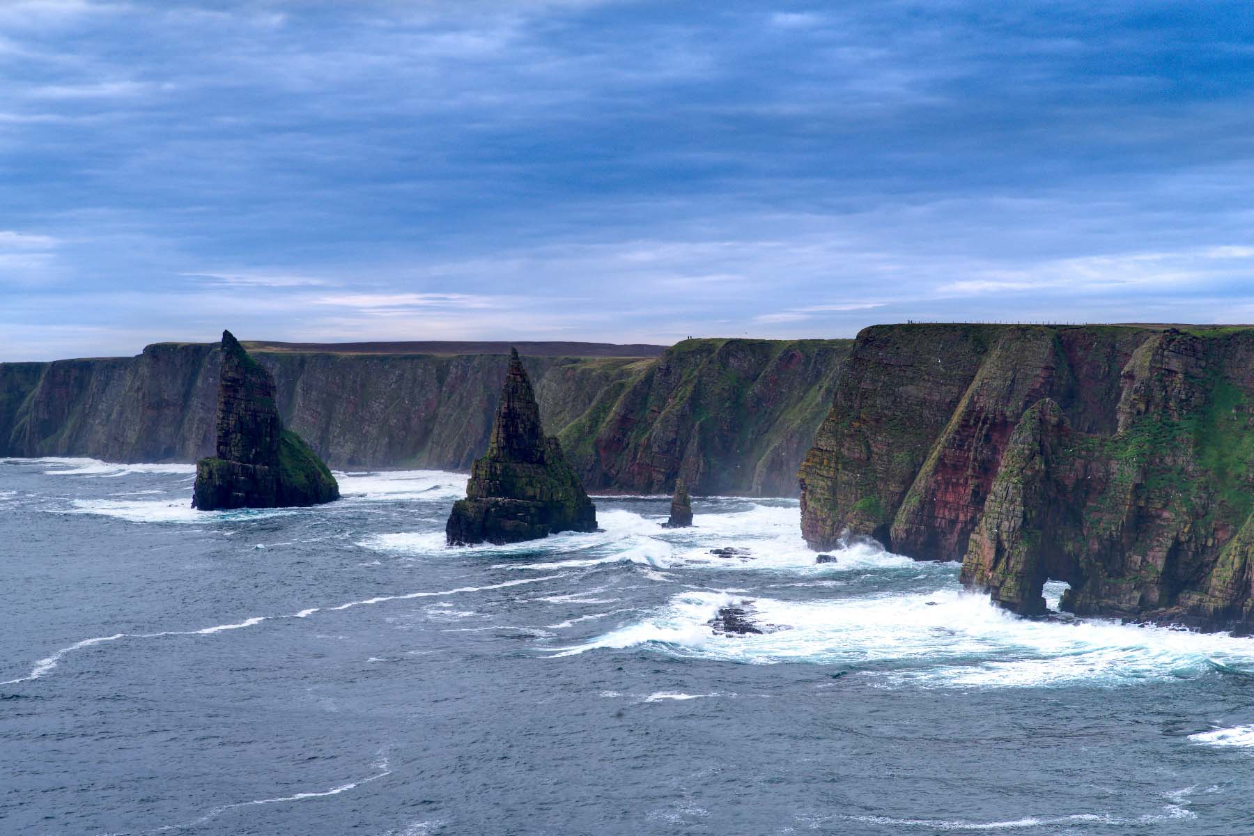
At John o’ Groats you reach the cliché and discover it’s still worth the drive. The famous signpost, the colourful row of huts, the clink of caravan doors and the chatter of accents from all over Britain – it’s busy, sometimes a bit kitsch, but there’s a genuine “end of the road” buzz to it. You stand at the edge of the harbour and look out across the Pentland Firth, where the sea races between mainland and islands in powerful tides that have wrecked more than one ship.
This spot has lured travellers for generations, from Victorian tourists to cyclists finishing charity rides with salt-streaked faces. You join the ritual: a photo, a wander along the shore, maybe fish and chips in the breeze. But it’s also a beginning. The low, dark shapes on the horizon are Orkney, and the ferries plying back and forth feel like stepping stones. As you watch them come and go, you feel the pull of the islands and know your journey isn’t over yet it’s just about to lift off the mainland.
Stromness greets you from the water, a tight row of stone houses clinging to the shoreline as the ferry noses into the harbour. You step onto cobbled streets that smell faintly of salt and stone dust, doorways opening almost straight onto the sea. The town curves round its sheltered bay, fishing boats nodding at their moorings while gulls argue overhead. Duck in and out of narrow closes, find a coffee in a tiny café, and feel how quickly Stromness starts to wrap itself around you like a well-worn jumper.
But the real scale of Orkney hits you when you drive out towards the Ring of Brodgar. The road threads through low, open farmland until the standing stones suddenly appear on a natural rise, encircled by lochs and big, shifting skies. You walk the path around the ring, wind tugging at your jacket, and it feels as if you’ve stepped sideways in time. Some of these stones have been watching storms, sunsets and solstices for over four thousand years. Later, back in Stromness with the harbour lights flickering on the water, you realise how close the deep past sits to everyday life here.
This route takes you from the hairpins of the Bealach na Bà at Applecross all the way to the big skies of Orkney, stitching together some of the most dramatic coastline in the UK. You get the full North-West Highlands hit: towering Torridon peaks, white-sand beaches around Gairloch and Assynt, and those long, empty stretches of single-track hugging sea lochs and cliffs. It’s basically the NC500’s greatest hits, then you keep going.
Ullapool, Lochinver and Durness break the journey up with proper little harbour towns and villages ideal for stocking up, grabbing a good meal and crashing at a campsite right on the water. The final leg from John o’ Groats across to Orkney flips the vibe: suddenly you’re into wide, rolling islands, stone circles, sea stacks and quiet bays where you can park up and feel like you’ve got the place to yourself.
By the time you reach Stromness and Kirkwall you’ve experienced mountain passes, Atlantic beaches, high cliffs, ferry crossings and some of the darkest night skies in the UK. It’s a really clean “Highlands into Islands” narrative: wild west coast, extreme north, then ancient Orkney to finish.
This route is loaded with easy wins. Around Applecross and Torridon you’ve got short, steep hill walks with huge pay-offs even a 1–2 hour wander above the Bealach gets you mad views back down the pass. North of there, Ullapool is perfect for a boat trip out into the Summer Isles or a quick leg-stretcher up Ullapool Hill before camping at Ardmair or similar coastal spots we’ve marked.
Assynt is where it starts to feel other-worldly: Suilven, Stac Pollaidh and Quinag all offer iconic day hikes if you want something bigger, or you can just bounce between beaches and viewpoints without committing to a full mountain day. Around Durness and the north coast you’ve got Smoo Cave, Balnakeil Beach and plenty of short cliff walks that are right on the driving line.
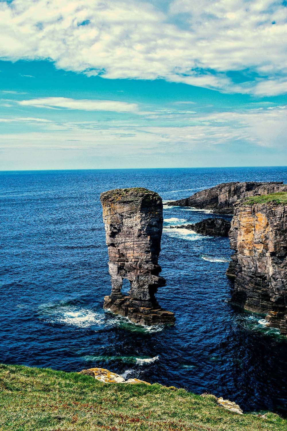
Once you’re over to Orkney, it switches to history and seascapes. You can hop between Skara Brae, Ring of Brodgar, the Italian Chapel and coastal walks like Yesnaby without ever straying far off the main road. Stromness and Kirkwall are easy base points park up at one of the campsites we’ve flagged and do little loops out to whatever mix of archaeology, cliffs and quiet bays you’re into.
You’re never that far from a solid feed on this run. Early on, Applecross Inn is the obvious stop exactly the sort of place you want after dropping off the pass, with local seafood and proper pub food. Ullapool has a cluster of good options around the harbour (think fish and chips, seafood shacks, and pubs that actually care about their menu rather than just being wet-led).
Up the north coast, Durness usually handles the “we’re in the middle of nowhere and starving” moment with cafés and hotel bars doing big portions. Once you’re on Orkney, Stromness and Kirkwall both punch above their weight for food: harbour-side bistros, pubs doing solid local produce, and a few nicer restaurants if you want a treat night at the end of the trip. The POIs we’ve picked for the map lean towards reliably well-reviewed spots you can aim for each day.
The route is built around a backbone of campsites and campervan stops roughly every 25–30 miles, so you’ve always got options without needing to book every single night months ahead. Expect a mix of simple grassy pitches with big views (Applecross, Assynt, Durness) and more serviced holiday-park style sites with showers, laundry and hookups closer to Ullapool and Thurso/John o’ Groats. A few of the campsites sit right on the beach or a sea loch, which makes sunrise/sunset stops easy content.
If you want proper beds sprinkled in, we’ve threaded in some 3★–4★ options in the key hubs – think small harbour hotels in Ullapool or Durness, then a “treat” stay on Orkney in or near Kirkwall/Stromness to finish. You can easily run this as full-time van life, or alternate between nights on campsites and a couple of hotel resets to do laundry, charge everything and have a slower breakfast before hitting the road again.
TopStops is built to be used like a shared guidebook, not a strict itinerary.
Browse the routes to see how others have travelled an area, check the map for regularly recommended stops, and get a feel for the journey with photos, highlights, and quick info on each place. When you’re ready, follow the route yourself or adapt it to your own trip.
If you discover a spot we’ve missed, submit it. The best community suggestions get added to the map, so every route slowly improves with real travellers’ input.
Do you know somewhere we should feature in our route? Message us and we’ll get it added.


