
This route carries you along the ragged edge of the west, from wild North Mayo through Achill and Connemara to the music and ferries of Clare. You begin in Bangor Erris among bogs, lakes and long empty roads, then slip out towards Achill where Keel, Dugort, Dooega and Bleanaskill stack up beaches, cliffs and tiny harbours under the heavy shoulder of Slievemore. Mulranny and Rockfleet bring softer inlets and old stone into view before Westport pulls you into one of the liveliest small towns in Ireland.
From there you follow the curve of Connemara, where granite hills and peatland run straight to the sea. Letterfrack, Omey and Sky Road show you different ways the land meets Atlantic light. The N59 takes you through a slow sequence of lakes, moor and mountains until the road unravels onto the island lacework of Lettermullan. Galway City shifts the rhythm with street music and packed pubs, then Kinvara and Doolin bring you back to quieter harbours and wave noise. By the end you have crossed several kinds of wildness, from empty bog to bright city, and finished with your feet almost on the ferries for the Aran Islands and the cliffs just beyond.
Bangor Erris feels like a small outpost on the edge of something vast. You arrive through a landscape of bog, low hills and scattered lakes, where long straight stretches of road disappear into weather rather than horizon. The village gathers around a junction and a bridge, with houses and shops huddled close to the river. It has the quiet, practical air of a place that serves farmers, fishers and wind battered travellers in equal measure.
Step away from the main street and the sky seems to grow again. You see distant ridges, dark water and wide, brown peatlands cut by narrow drains. The air smells of wet earth and turf smoke when fires are lit. Bangor Erris sets the tone for the start of this route. It reminds you that the west is big and that you are only just beginning to trace its outline.
Keel West sits at the wide end of Achill Island, close to the great curve of Keel Beach and under the looming bulk of Minaun Heights. The road runs past fields and low houses towards the sand, where Atlantic surf rolls in on a big, steady rhythm. On clear days, cliffs and headlands frame the bay in deep blues and greens. On rougher ones, white water explodes along the shore.
From here you can walk the beach, watch surfers play in the waves or look back at Slievemore rising behind the village in slow layers of shadow. The air tastes of salt and peat smoke. Keel feels like a place both exposed and homely, somewhere people have learned to live right on the weather line. It is a strong, Atlantic soaked step into Achill.
Dugort Beach curls under the northern side of Slievemore, a pale stripe of sand between the mountain’s steep flank and the open sea. The village is scattered around the shore, white houses and small roads tucked into the folds of the land. The water here can look almost glassy on calm days, grey and steel coloured with the mountain reflected across it.
Walk along the sand and you feel Slievemore at your back the whole time. The slope rises so sharply that the sky seems to sit lower on that side. Old holiday homes and quiet lanes give the place a slightly faded, timeless feel, as if summers have been slowly repeating here for decades. Dugort is a more contemplative counterpoint to Keel, a place that invites quiet walks and long looks at the mountain.
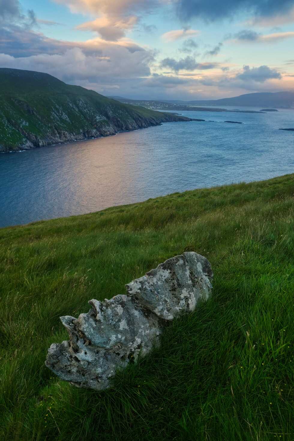
Dooega sits near the western edge of Achill, a tight cluster of houses gathered above a small bay. The road in twists and dips, fields dropping towards cliffs and small coves where the Atlantic presses hard against the island. The village feels tucked in, trying to find shelter while still looking out to sea.
From the headlands nearby you get big, unbroken views of water, with distant islands and rock stacks marking the horizon. The wind often has a raw edge here, and the sound of waves carries up from below even when you cannot see the shore. Dooega gives you a strong sense of how exposed Achill really is, and how closely people live with the weather.
Bleanaskill feels like a pause in the drama, a small inlet and harbour on Achill’s sheltered side. Boats lie still in calm water, ropes slack, and the hills beyond seem to soften as they meet the sea. Old stone piers, seaweed on the rocks and the quiet clink of rigging give the place a gentle, working rhythm.
It is the kind of spot where you park, step out and immediately breathe a little deeper. Lanes weave along the shore, giving glimpses into gardens and over low walls to the bay. Bleanaskill reminds you that even on a wild island there are corners of calm, and it makes a nice shift of tone before you leave Achill behind.
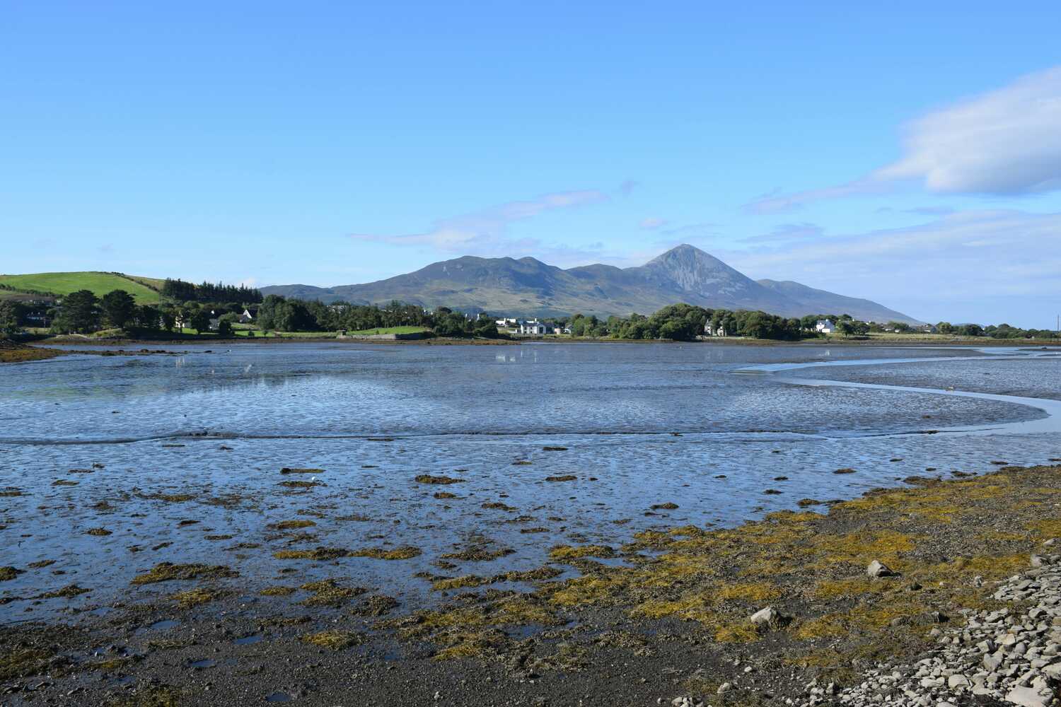
Mulranny sits where land, sea and bog seem to meet in a perfect three way handshake. The village looks out over Clew Bay and its scatter of drumlin islands, while behind, the dark lines of the Nephin Beg range stretch away. Old hotels and houses sit above a causeway and salt marsh, the railway line that once ran through now reborn as the Great Western Greenway.
From the old station or the footbridge you get sweeping views across tidal flats and shifting channels. On a calm evening, the water reflects sky and mountains in soft layers. On rougher days, wind drives the sea hard against the shore. Mulranny feels like a hinge in the route, a place that connects the wildness of Achill with the more layered, intricate world of Clew Bay and Westport.
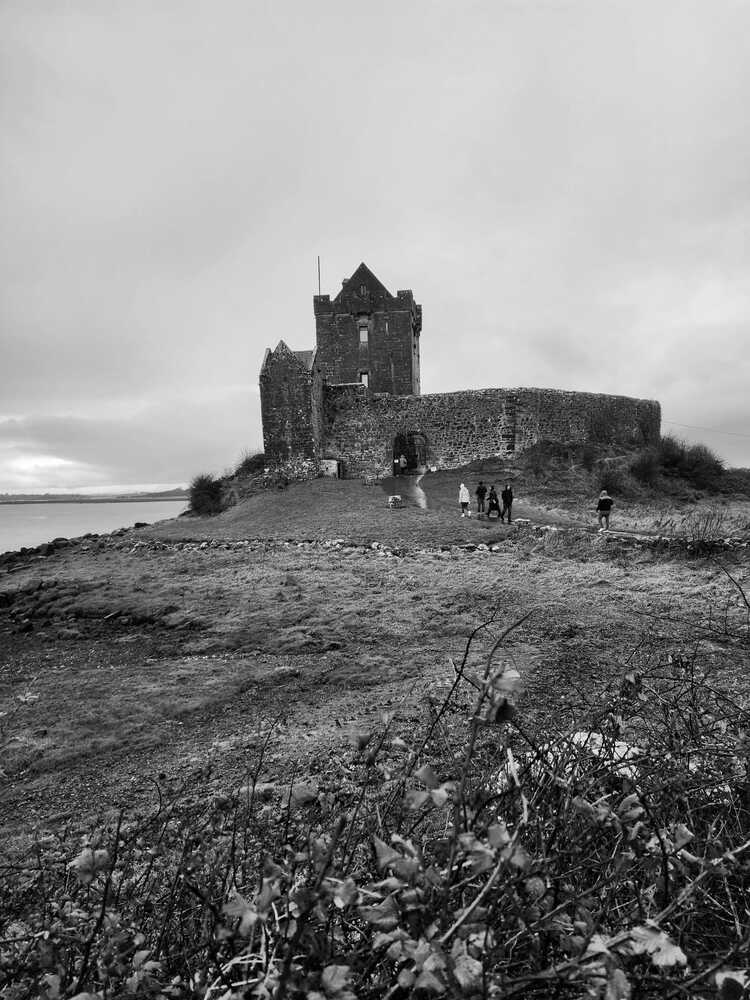
Rockfleet Castle stands alone by the shore, a tall, square tower house watching over the shallow waters of Clew Bay. You reach it along narrow lanes that twist between fields and stone walls, then suddenly the castle rises in front of you, simple and solid against sky and sea. At low tide, the ground around it is all mud and weed and the faint smell of salt. At high tide, water laps right against its base.
The association with Grace O’Malley, the pirate queen of the west coast, adds flavour, but even without that story the place has presence. Gulls wheel overhead, the bay stretches away in soft greys and blues, and the castle itself feels almost like a stranded ship of stone. It is a quiet, atmospheric stop that ties the landscape to a more human scale of power and ambition.
Westport is one of those towns that feels instantly welcoming. The tree lined Mall, stone bridges and colourful shopfronts make the centre feel both neat and lively. The Carrowbeg River threads through in bright channels, and beyond the roofs the distinctive cone of Croagh Patrick stands out against the sky.
The town is full of pubs, cafés and music, especially in the evenings, and there is a constant low hum of visitors mixing with locals. Westport House and the grounds around it add a note of stately calm, while the quay down the road opens onto views of Clew Bay and its islands. It makes a natural base, and on this route it is a point where bog and island give way to Connemara granite and lake country just to the south.
Letterfrack sits near the entrance to Connemara National Park, a small village pressed between sharp hills and the waters of Barnaderg Bay. It feels like a gateway into the rough heart of Connemara. Mountains rise in folded ridges just behind the houses, and the road from here splits towards Kylemore, Tully Cross and the Atlantic.
Walk up into the National Park and you gain height quickly, the village shrinking below while the quilt of bog, lake and rock spreads out in front. Back at ground level, Letterfrack’s few pubs, shops and cafés feel like a cosy cluster in quite a big landscape. It is a place to reset, pick up a trail map and remember that much of Connemara is best met on foot.
Omey Island is reached across a tidal strand, which makes simply getting there part of the experience. At low tide you drive or walk over firm, wet sand, following poles that mark the safe line. At high tide the route disappears under shining water and the island stands quietly on its own again.
Once you are there, small roads and tracks loop between fields, old ruins and rocky shore. The Atlantic presses in on all sides, but the interior feels gentle and human. Grass, stone and sand mix in shifting patterns. Omey reminds you how much the sea dictates the rhythm of life here. You watch the time with one eye on the tide tables.
Sky Road climbs out of Clifden and loops above the bay in a wide arc, offering some of the best views in Connemara from the comfort of your car. As you rise, the town falls away and a tangle of inlets, islands and headlands steps into view. The road itself is narrow, with grassy banks and stone walls, but lay bys and viewing points let you pull safely aside.
From the higher stretches you can see far out to the Atlantic, with scattered houses and fields laid out below like a patchwork. Sun, cloud and showers constantly repaint the scene. It is a place for slow driving and repeated stops, even if you only mean to “quickly” take a photograph. Sky Road earns its name without fuss.
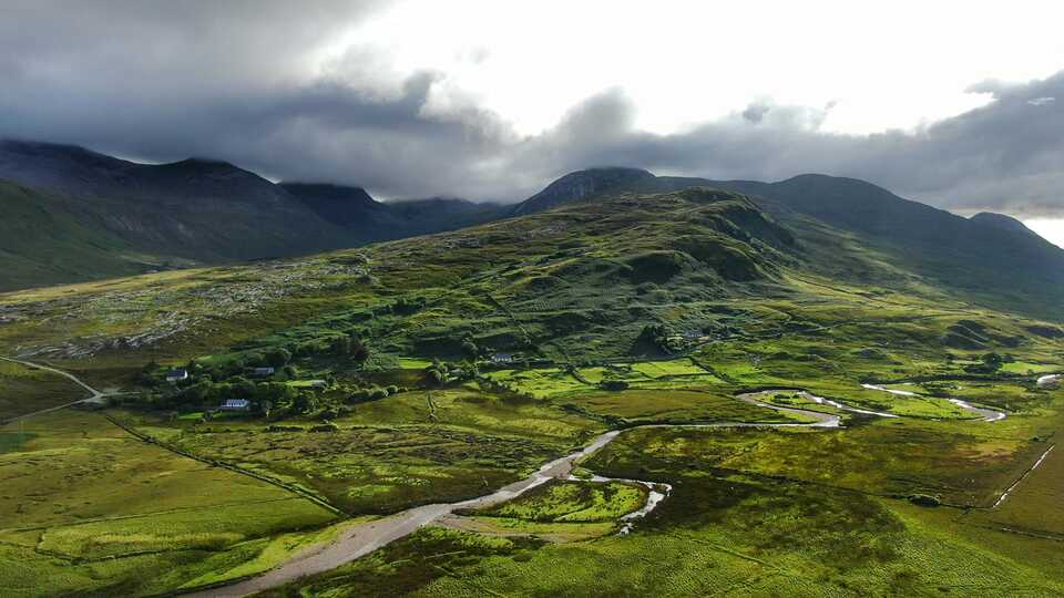
The N59 through Connemara is more than just a connecting road. It is a rolling gallery of lakes, bog and mountains that seems to change character every few kilometres. One moment you are alongside a still lough, reeds trembling at the edge, the next you are between steep rocky slopes that feel almost lunar.
Pockets of forest, scattered cottages and occasional sheep on the verge are the only real signs of human presence. The road curves gently, giving you time to take in the reflections, the shifting light on the Twelve Bens and Maumturk ranges, and the constant play of water and stone. It is a stretch where the drive itself becomes one of the main experiences.
Lettermullan lies near the outer edge of the Connemara island chain, reached by a daisy chain of causeways and bridges from the mainland. Each crossing takes you a little further out into the Atlantic, until you are surrounded by low, rocky fields, tiny coves and a horizon full of nothing but sky and scattered islets.
The village is modest, with houses spread thinly across the land. Irish is part of the everyday language here, and the pace feels slow and self contained. The sea is never far. You hear it in the distance, see it glittering between houses and stone walls, and smell it on the air. Lettermullan gives you a quiet sense of having reached the edge of the map.
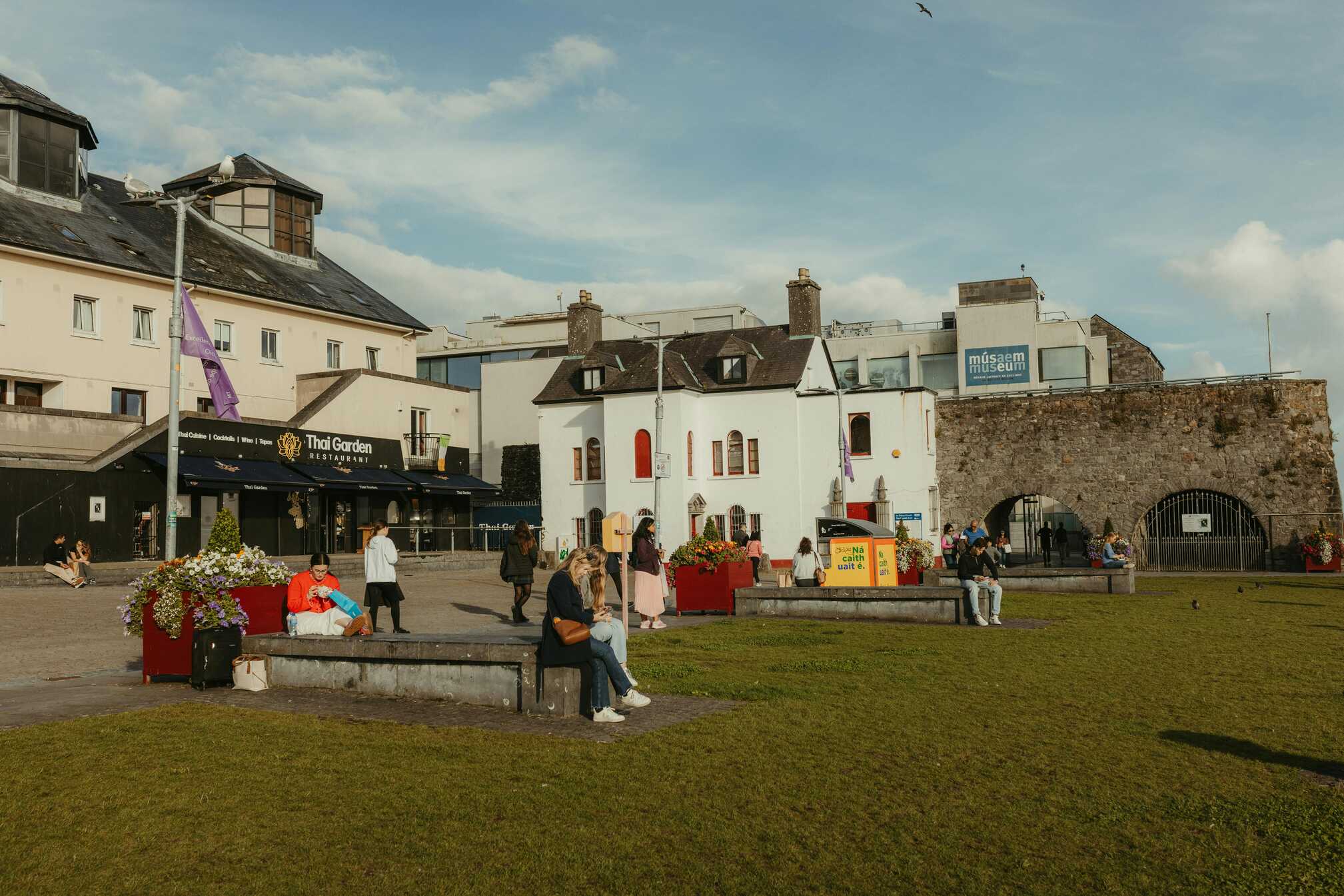
Galway City arrives like a rush after the open spaces of Connemara. Suddenly there are street performers, buskers, bright shopfronts and crowds flowing through the Latin Quarter. Eyre Square, Shop Street and the lanes around the Spanish Arch all hum with energy, especially in the evenings when music spills out of pub doorways.
Down by the Claddagh and the Long Walk, the Corrib meets the bay, and you can watch waves and swans sharing the same strip of water. Salthill’s prom gives you a long, easy seafront walk if you need air. Galway feels young, creative and outward looking, the kind of place where you could stay for days, but on this route it is your brief taste of city life between wild stretches.
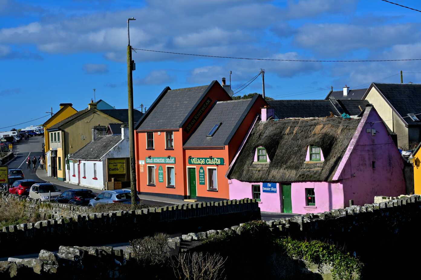
Kinvara is a softer harbour village on the southern edge of Galway Bay. Boats lie at anchor in the sheltered water, their masts making a small forest of lines against the sky. The main street sits just back from the quay, a short run of brightly painted pubs, cafés and shops that feels intimate and relaxed.
Across the water, Dunguaire Castle crouches near the shore, giving the scene a neat, storybook focal point. At high tide the reflections are picture perfect. At low tide you see mud, weed and curving channels. Kinvara feels like an easy place to pause, hear a tune in a pub and watch the light on the bay slow down your breathing.
Doolin sits near the edge of the Burren and the cliffs, a scattered village tied together by music, ferries and the sea. Pubs here are famous for traditional sessions, and on many evenings you can simply walk in, find a corner and listen as fiddles, flutes and voices fill the room. Outside, narrow roads run down to a pier where boats head for the Aran Islands and sea trips along the Cliffs of Moher.
The coastline around the pier is all rock shelves, spray and the steady push of the Atlantic. Inland, the grey limestone pavement of the Burren rises, patterned with cracks and wildflowers. Doolin feels like a threshold again, this time between land and sea, stone and sound. It is a fitting place to end, with the promise of more beyond if you decide to keep following the coast.
This route traces a long, shifting edge of the Atlantic from the boglands of North Mayo to the music filled pubs of Doolin. You start in Bangor Erris, where empty roads run between peat bog and scattered lakes, then roll out onto Achill, with Keel, Dugort, Dooega and Bleanaskill giving you a full sweep of island moods. One minute you are on huge surf beaches under the shoulder of Slievemore. The next you are at a quiet inlet with boats resting in still water. Mulranny and Rockfleet soften things with salt marsh, islands and a solitary tower house, then Westport pulls you into one of the west’s liveliest small towns.
From there the landscape steps into Connemara. Granite hills, dark lakes and open bog lie around Letterfrack, Omey and Sky Road, all under a restless sky. The N59 itself feels like a moving viewpoint, sliding between mountains and water until the land breaks into causeways and islands at Lettermullan. Galway City changes the tempo with busy streets and live music, then Kinvara and Doolin reel you gently back into harbour life and wave noise. By the end you have moved through several kinds of wildness, finishing in a village that feels like a doorway to the Aran Islands and the Cliffs of Moher.
Early in the route, take time to simply walk and look. Around Bangor Erris, short detours along bog tracks or lakeside lay bys give you a real sense of how big and quiet the interior is. On Achill, walk Keel Beach, climb a little on the slopes above Dugort for views over the bay, and poke down to the smaller coves near Dooega. Bleanaskill rewards a slow wander around the harbour wall, listening to the gentle sounds of a sheltered shore.
Mulranny is perfect for a stretch of the Great Western Greenway, where you can walk or cycle along the old railway with Clew Bay spread out beside you. Rockfleet Castle is a short, atmospheric stop, ideal for photographs and a moment of stillness. In Westport, explore the town on foot, visit Westport House and take a stroll at the quay.
Once in Connemara, head into the National Park from Letterfrack for one of the shorter hill walks if the weather is kind, or choose a low level trail if it is not. Time your visit to Omey Island with the tide so you can cross the strand and wander its tracks and shore. Drive Sky Road very slowly, using each viewing point, and treat the N59 itself as a scenic experience rather than just a way of getting somewhere. At Lettermullan, explore back roads to small piers and lookouts where the Atlantic feels close but calm. In Galway, walk the Latin Quarter, the Claddagh and Salthill prom. Towards the end, enjoy a harbour wander in Kinvara, then in Doolin walk down to the pier for views of crashing waves and distant cliffs, or book a boat trip to the Aran Islands or along the cliff base if the sea behaves.
This route gives you a good mix of low key local spots and lively town choices. In the Bangor Erris and Achill stretch, you are looking mainly for village cafés and pubs serving simple, hearty food that suits walkers and surfers. Keel and Dugort usually offer enough places to grab a hot drink, a bowl of chowder or a generous plate after a windy beach walk.
Mulranny and Westport expand the options. Mulranny has hotel dining rooms and smaller cafés with views over the bay. Westport is one of the best places on the route for eating out, with everything from bakeries and coffee spots to busy pubs and restaurants that focus on local produce and seafood. It is worth planning at least one evening meal here.
In Connemara, food tends to cluster around villages. Letterfrack has a handful of pubs and cafés that feel very welcoming after a day on the hills. Clifden, just off your Sky Road loop, has a strong choice of restaurants and bars, making it a good lunch or dinner stop. Further along, you will find smaller, scattered options near the N59 and out towards Lettermullan, often simple places serving fresh fish and home baked cakes.
Galway City gives you the broadest spread of all, from casual street food and cafés to refined dining, so it is sensible to arrive hungry. Kinvara has a few cosy pubs and cafés near the harbour where you can eat within sight of the boats. Doolin finishes things off with pub food and seafood, often eaten to the sound of live trad sessions, which makes even a simple meal feel like part of the experience.
There are plenty of ways to shape your overnights on this route. You could begin with a quiet stay around Bangor Erris or on Achill itself, where small guesthouses and family run B and Bs give you easy access to beaches, cliffs and island roads. Keel and Dugort both make strong bases if you want to wake up close to the sea.
Mulranny works nicely as a midpoint stop, especially if you want to use the Greenway or enjoy views over Clew Bay without the buzz of town. Westport, by contrast, suits a longer stay. It has a wide range of accommodation, from simple guesthouses to larger hotels, and makes a great base for exploring both north into Mayo and south into Connemara.
Within Connemara, Letterfrack, Clifden and the villages along the N59 offer plenty of B and Bs, small hotels and self catering cottages. Letterfrack puts you close to the National Park. Clifden gives you more evening options. If you want something quieter and more remote, look at stays out towards Lettermullan and the surrounding islands, where stone walled fields and sea views are standard.
Towards the end of the route, Galway City provides classic city hotels and apartments, ideal if you fancy a night of music and restaurants. Kinvara offers smaller, harbour side places that feel calm and friendly. In Doolin, guesthouses, hostels and inns cluster along the lanes, often with views towards the ocean or the Burren hills. It is an excellent final base, especially if you plan to visit the Aran Islands or the Cliffs of Moher before looping back inland.
TopStops is built to be used like a shared guidebook, not a strict itinerary.
Browse the routes to see how others have travelled an area, check the map for regularly recommended stops, and get a feel for the journey with photos, highlights, and quick info on each place. When you’re ready, follow the route yourself or adapt it to your own trip.
If you discover a spot we’ve missed, submit it. The best community suggestions get added to the map, so every route slowly improves with real travellers’ input.
Do you know somewhere we should feature in our route? Message us and we’ll get it added.

