

This route feels like a full circuit through the Peak District’s greatest hits, stitched together into one continuous loop. You peel off the M1 at Junction 29 and almost immediately swap straight tarmac for dry-stone walls, moorland and old estates. Stanton Moor and Nine Ladies ease you in with heather and myth, while Chatsworth and Arbor Low remind you how tightly grand houses and deep prehistory sit together in this landscape. From there, you slide into pub-and-village territory at Calver and Hathersage, with Higger Tor, Burbage Valley and the Fox House giving you that classic gritstone edge experience big skies, rough rock, wind in your face.
Further in, the mood shifts to water and limestone. Ladybower’s long, calm surface hides drowned villages, while Castleton, Mam Tor and the surrounding ridges show you how landslips, caves and old forts all coexist in one tight area. Finally, you drift south into the softer White Peak around Ilam, Dovedale and Chrome Hill, where green fields wrap around sharp limestone spines and the Dragon’s Back gives you a last, playful run of climbs and views. It’s a route of constant contrasts dark moor to bright dale, engineered reservoirs to toppled stone circles with barely a dull mile between them.
You slip off the M1 at Junction 29 and almost immediately feel the shift from service-station glare to something softer. The road begins to roll and narrow, hedgerows close in, and ahead the horizon starts to wrinkle into low, dark shapes. You’re leaving the straight-line logic of the motorway behind and trading it for stone walls, sheep-dotted fields and sudden, teasing views of the moors. It’s that familiar Peak District moment where your shoulders drop a notch and the drive itself becomes part of the trip.
Villages appear in short bursts a row of cottages here, a church spire there – and you get flashes of gritstone edges in the distance. Old mining and mill towns sit in the dips, modern life ticking along as lorries nose past dry-stone walls and bus stops. Junction 29 isn’t somewhere you linger, but it’s the hinge that turns you from everywhere-else England into the beginning of a proper moorland loop.
Nine Ladies sits quietly on Stanton Moor, a small stone circle tucked among heather, bilberry and birch. You park a little way off and follow sandy paths through the trees, the ground slowly rising until the stones appear ahead modest, weathered and spaced like a group of people frozen mid-conversation. Legends say they were dancers turned to stone for playing music on the Sabbath; whatever the truth, there is something oddly social about the way they stand.
Around you, the moor stretches out in soft rises, old quarries and boundary stones hinting at centuries of human use. In late summer the heather turns the whole place purple, and skylarks scribble songs high overhead. This isn’t a grand monument; it’s smaller, more intimate, easy to sit beside with a flask and let your thoughts drift. The views across to the Derwent valley remind you how much landscape is stacked around you in every direction.
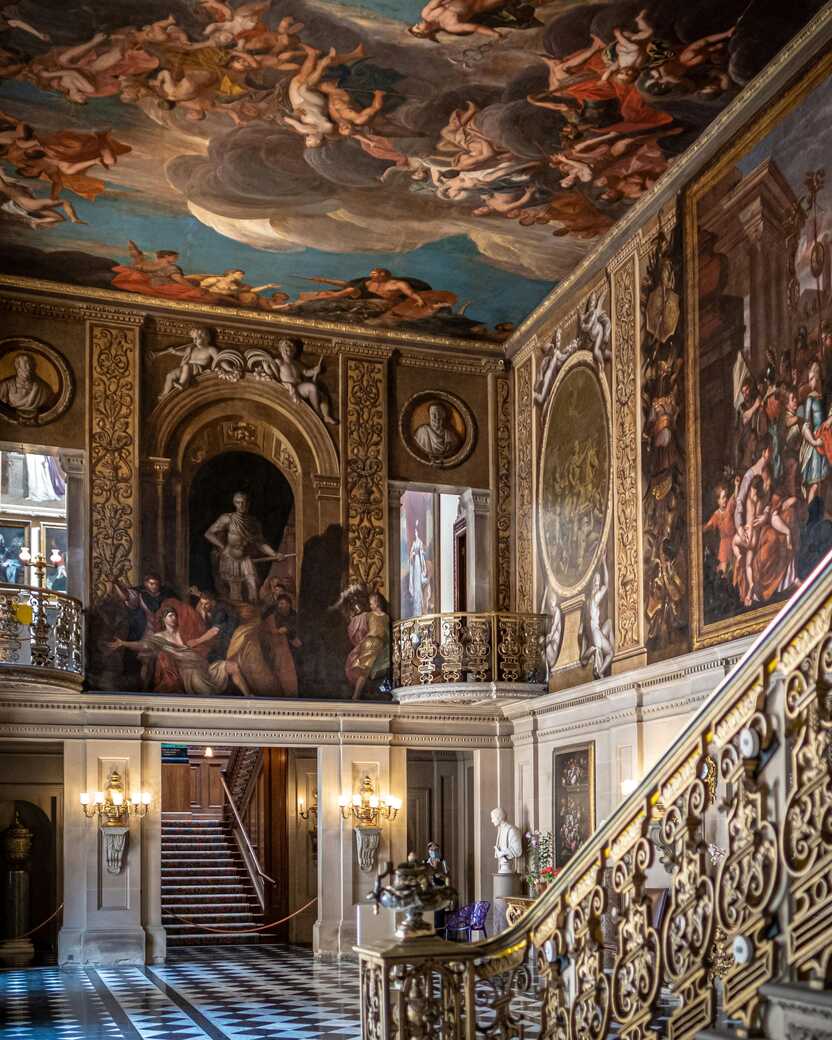
Chatsworth House announces itself long before you reach the gates. You glimpse stone façades through trees, catch sight of the golden window frames glittering in the sun, and then suddenly the whole thing opens up: house, river, bridge and sweeping parkland in one broad, carefully composed view. This is aristocratic theatre on a grand scale, but you don’t need to go inside to feel the effect.
Walk the grounds and you pass centuries of landscaping sculpted hills, clumps of trees placed just so, herds of deer ghosting through the grass as if they own the place. The River Derwent curves lazily below the house, its surface disturbed by the occasional duck or drift of leaves. Chatsworth has starred in more period dramas than you can count, yet when you’re there it feels surprisingly relaxed: families picnicking, walkers cutting through on long routes, gardeners trundling barrows along gravel paths. It’s both stately home and everyday backdrop.
Arbor Low feels raw and old in a way that bypasses words. You arrive along narrow lanes and low fields, then climb a short way to a grassy plateau where a ring of stones lies toppled within a deep circular bank and ditch. The slabs are massive even on their sides, lichen-patched and cool under your fingers, with a central cove hinting at rituals long since forgotten.
From up here the view rolls out in all directions patchwork farms, distant ridges, the faint line of roads stitching it all together. There’s no visitor-centre fanfare, just wind, skylarks and the occasional sheep nosing between the stones. Some call Arbor Low the “Stonehenge of the North”, but it feels more elemental than that: less reconstructed, less explained, more yours to experience. Standing on the bank, coat tugged by the breeze, you get that prickling sense of deep time that the Peaks hide so well under their green surface.
The Derwentwater Arms sits snug in Calver, looking out across the valley to Curbar and Froggatt edges. After miles of moor and stone walls, it’s exactly the kind of place you want to roll into: low, solid building, warm light at the windows, the quiet clink of glasses and cutlery drifting out when the door opens. Inside, you’re likely to find muddy boots, damp jackets and maps spread on tabletops as walkers and climbers refuel.
Step outside with a drink and you can see the gritstone edges catching the last light, dark cliffs topped with silver birch and heather. This is the kind of pub that anchors a whole area somewhere locals weave into their week and travellers adopt as a temporary basecamp. On this route it’s less a tick-box stop and more a reset button: good food, a pint, and a chance to let the day’s miles settle in your legs before you head back up onto the high ground.
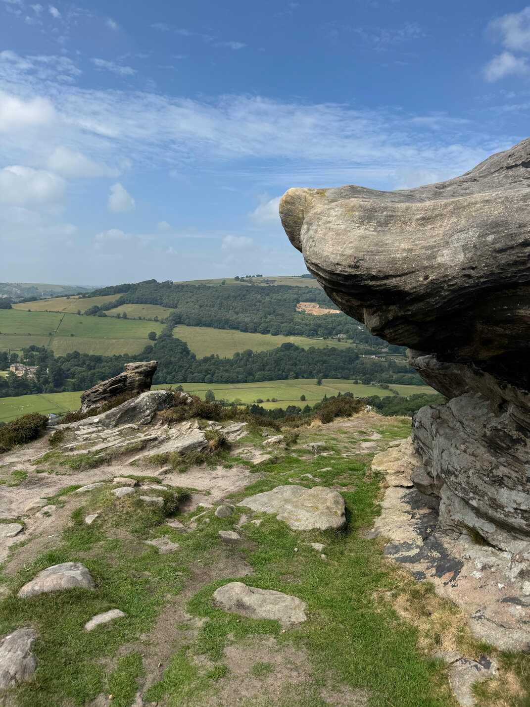
Higger Tor rises out of the moor like a weathered ship of stone. You park on the roadside and strike out across rough, springy turf, the wind tugging at your clothes as the plateau of gritstone blocks grows larger ahead. The climb is short but sharp enough to wake you up, and then suddenly you’re on top, wandering between tumbled boulders and rock edges that drop into steep, bracken-covered slopes.
From up here, the view is pure Dark Peak: Carl Wark’s ancient fort platform close by, Burbage Valley cutting a clear line, and the long, distant ribbon of Stanage Edge on the horizon. On clear evenings the light pours along the ridges, turning the rocks warm orange and the heather almost black by contrast. This is the kind of spot where you stay “just until the next cloud passes” and find you’ve watched a whole weather front move through.
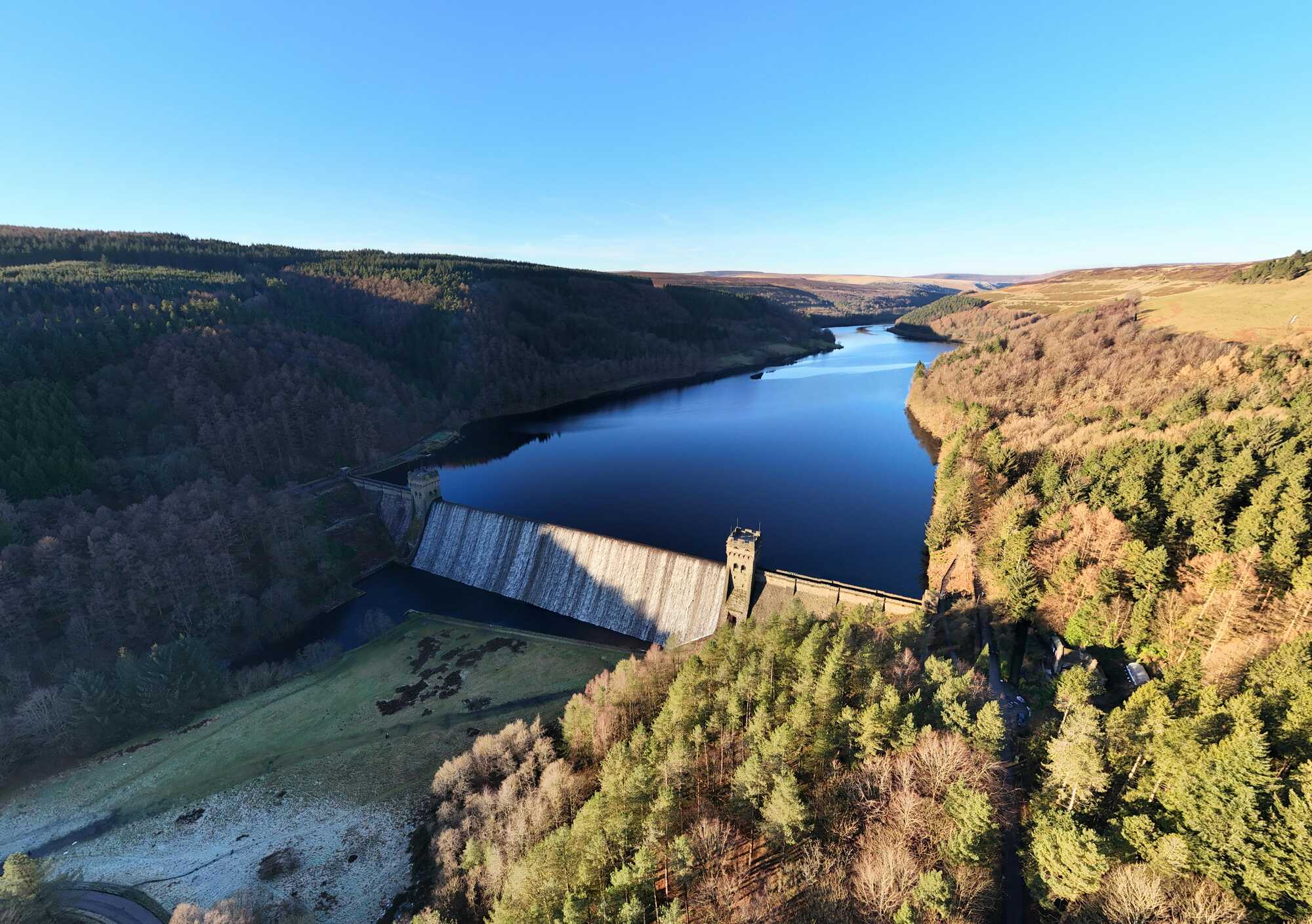
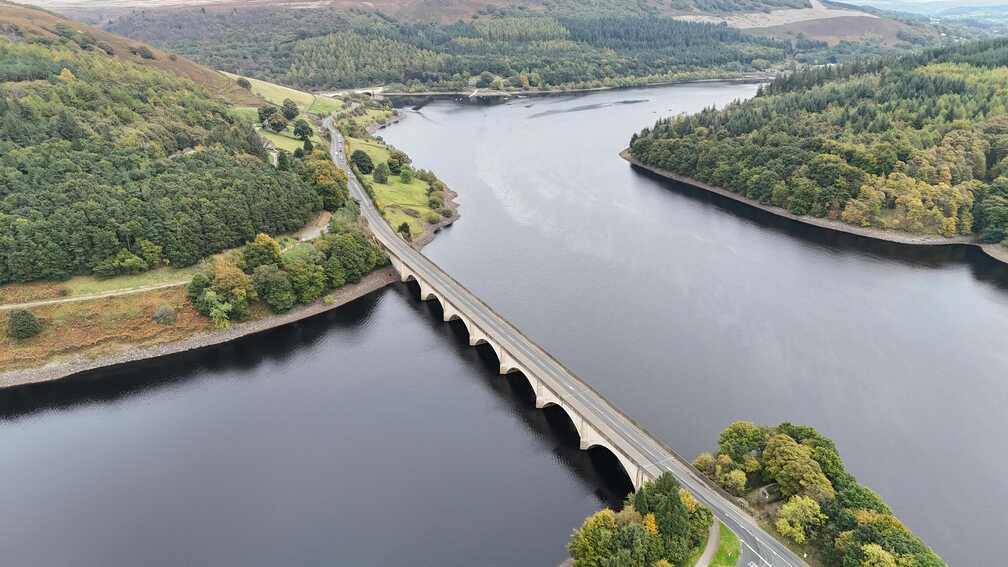
Ladybower sits like a long, reflective ribbon folded between steep hillsides. You drop down through trees and catch glimpses of water between trunks before the reservoir suddenly opens out beneath the road, bridges stretching across its narrowest points. On still days the surface is a perfect mirror for sky and hillside; on windier ones it breaks into ranks of small, racing waves.
Park up and you can follow shoreline paths into quiet bays where drowned lanes disappear into the water and old tree stumps sit just below the surface. The famous plugholes – those huge, circular overflow shafts add a surreal, almost sci-fi note when the water’s high. Above you, conifer plantations and open moor wrap the whole basin, with the scars of old landslips and quarries reminding you this landscape is still shifting. Ladybower is a place of engineered calm layered over older, lost villages – peaceful now, but with stories under the surface.
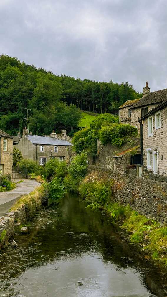
Castleton is the Peak District in miniature. You roll in under the shadow of Mam Tor and Lose Hill, narrow streets threading between stone cottages, pubs, cafés and outdoor shops. Peveril Castle perches on its rocky spur above the village, watching the comings and goings as it has done for centuries, even if the cargo has shifted from wool and lead to rucksacks and ice creams.
You can head underground into Blue John and show caves, where mineral veins and cathedral-sized chambers sit hidden beneath farmland, or climb straight out of the village onto the ridges. On summer evenings, the warm glow from pub windows spills into the street while the last light catches the hills beyond; in winter, it’s a cosy refuge from sleet and wind. Either way, Castleton feels like a natural hub on this route somewhere you can sleep, eat, explore and decide which edge or valley to tackle next.
Mam Tor’s nickname, the “Shivering Mountain”, makes sense once you see the huge landslip scarring its eastern flank. You start from the car park and join a well-laid path that climbs steadily to the summit, flagstones carrying you over turf that thousands of boots have worn in. Even halfway up, the views begin to spread: Edale and Kinder plateau on one side, Castleton and the Hope Valley on the other.
At the top, a trig point marks your spot on a broad, grassy dome, often fringed with wind-blown walkers taking photos and sipping from flasks. The ridge path running out towards Lose Hill is one of the most iconic in the Peaks, waving gently along the skyline like a slow, stone spine. This hill has an Iron Age fort buried under its surface and a reputation for restlessness, but for you it’s a breezy, big-view highlight a chance to see how the places you’ve driven through fit together from above.
Hathersage sits where moorland folds into the valley, a village with one foot in climbing folklore and the other in old mill history. You drive in past gritstone edges and find streets of stone houses, cafés and pubs, all stitched together by the sound of the River Derwent slipping quietly along the edge of town. This is gear-shop and café territory, where weekend warriors grab coffee before heading for the crags and locals carry on with school runs and shopping.
There are literary echoes here too: Charlotte Brontë stayed nearby, and some say Hathersage fed into her vision of Jane Eyre. The churchyard holds graves that have been tied, rightly or wrongly, to Robin Hood’s tales. Whether or not you care about that, the real pull is the location. Paths lead straight out of the village onto the surrounding hills, and coming back down to lights, hot food and a steep street under a dark, star-spotted sky feels like the right way to end a day on the edges.
Burbage Valley is a long, shallow scar running between ridges of gritstone, a place where rock, heather and water all sit in close company. You can park at either end and wander the track that follows the stream, the edges of Burbage North and South rising on either side like weathered ramparts. Climbers dot the crags in bright flecks, bouldering pads scattered like beetles below favourite problems.
The valley feels at once open and intimate: wide skies overhead, but steep sides that hold the sound of the beck and the wind. In winter, the rocks can be rimed with frost and the peat crisp underfoot; in summer, the bracken brushes your legs and the air smells of warm heather and gritstone dust. Old boundary stones and wheel ruts remind you that this was once a busy route for packhorses and peat-cutters, long before climbers and trail runners adopted it.
Fox House, perched at the junction of moorland roads, feels like a crossroads between worlds. The pub itself sits solid and welcoming, stone walls and low roofs braced against the weather that comes barrelling off the high ground. Out front, car parks fill with muddy vehicles, bike racks and walkers comparing routes over the roar of the main road. Step inside and the sound softens into clinks, chatter and the scrape of chairs on flagstones.
From here, paths thread off towards Burbage, Houndkirk and the Eastern Edges, making this as much a trailhead as a pit stop. You might pull in at the end of a long day on the moors, cheeks stung pink by wind, and wrap your hands around something hot while the windows steam up slightly. Or you park up at the start, pore over a map at a table, and step straight out into open country. Either way, Fox House feels like a familiar anchor on the edge of the wild.
Ilam appears almost suddenly in its own little bowl of green. As you drop in, steep, tree-clad hills rise up around a scattering of peaked-roof buildings that look oddly Alpine against the English landscape. The River Manifold and River Hamps meet nearby, and their combined water threads through parkland dotted with tall, slender trees and eccentric stone structures.
Ilam Hall, now a youth hostel, sits above the village with its arches and terraces, giving everything a slightly romantic, tucked-away feel. Walk the grounds and you’ll find views opening towards Thorpe Cloud and Dovedale, the limestone edges of the White Peak framing sheep-grazed pastures. It feels more like a country estate that forgot to fence itself off properly than a normal village, and it makes a gentle, slightly whimsical gateway to the limestone dales beyond.
Dovedale is one of those places that’s famous for a reason. You arrive to a modest car park and a small river, and then follow the path as the Dove squeezes into a steepening limestone gorge. The banks quickly rise into sheer white faces patterned with trees and ledges, and the path alternates between open riverside and short rocky squeezes.
The stepping stones are the star a line of flat rocks across the river that have launched thousands of childhood memories and the odd wobbly misstep. Beyond them, the gorge bends and narrows, caves and arches carved into the cliffs by time and water. On busy days, it’s full of families and walkers; on quieter ones you can hear nothing but the river, birds and your own footsteps. Either way, Dovedale feels like walking into a postcard: intensely pretty, easily accessible, but still with enough raw rock and height to make your heart lift.
Chrome Hill rises from the fields like the vertebrae of some long-buried creature. As you approach, its sharp, knuckled ridge stands out clearly against the softer hills around, green flanks dropping steeply to dry-stone walls and patchwork pastures. The path up is steep in places, hands occasionally coming into play, but you’re rewarded quickly with expanding views.
From the top, you can trace the Dragon’s Back running off in a series of humps, each one a reef of ancient limestone from when this area lay under warm tropical seas. Today it’s all wind, grass and sheep, the odd buzzard circling overhead. The contrast between the smooth farmland below and the jagged spine you’re standing on gives everything a slightly unreal, cinematic feel. It’s one of the few places in the Peaks where the land looks almost like a fantasy map drawing brought to life.
The Dragon’s Back is the name given to that run of hills near Chrome Hill, a string of steep little peaks that undulate across the landscape like a resting serpent. Walking it, you’re constantly climbing and dropping, lungs and legs working as the path crests one knoll after another. Each summit gives you a slightly different angle on the same scene: limestone ridges, green fields scored by walls, small farms tucked into sheltered folds.
There’s a satisfying rhythm to it effort followed by big views, then an easy descent before the next push. On clear days, the light picks out every ripple and fold in the ground; on mistier ones, the ridges loom in and out like something half-imagined. Finishing the Dragon’s Back feels like a fitting finale to this route: a last, playful test of your legs, and a reminder that under all this greenery lies a long, strange geological history that has shaped the Peaks into exactly the kind of landscape you’ve just spent days exploring.
This route strings together a lot of what people actually want from the Peaks: stone circles and moorland on the eastern side, the gritstone skyline around Higger Tor and Stanage, the reservoirs of Ladybower, and the limestone dales around Ilam, Dovedale, Chrome Hill and the Dragon’s Back. Toss in Nine Ladies, Chatsworth House and villages like Castleton and Hathersage and you’ve got both big landscapes and softer, country-house scenery on one line.
Nine Ladies and Arbor Low are quick prehistoric hits with big views. Higger Tor, Stanage and Burbage Valley are all fast-access grit edges – park up, walk 20–40 minutes and you’re on a ridge looking over half the park. Around Ladybower you’ve got dam-top strolls and forest trails. Further south, Ilam Park and Dovedale give you straightforward half-day walks with stepping stones and valley viewpoints, while Chrome Hill and the Dragon’s Back offer a short but punchy ridge if you’re happy with steep grass and hands-on sections.
Bakewell, Hathersage and Castleton act as food hubs filled with cafés and pubs. On the route itself, the Derwentwater Arms and Fox House both work as mid-drive stops with parking and solid pub food. In the dales, Ilam village tearooms and farm cafés around Longnor, Earl Sterndale and Tideswell make it easy to bolt lunch onto your walks without leaving the route by miles.
For vans and tents, there are plenty of small sites threaded along the route: simple fields near Nine Ladies and Arbor Low, bigger campgrounds around Bamford, Hathersage and Edale for the Ladybower/Hope Valley section, and quiet farm sites close to Ilam and the Manifold Valley. That gives you a natural rhythm of a couple of nights on the eastern edges and one or two in the southern dales. Indoors, the villages around Chatsworth have smart B&Bs and hotels, Castleton has several inns with rooms, and Hathersage, Bakewell and Ashbourne all work as fixed bases if you prefer day trips to moving every night.
TopStops is built to be used like a shared guidebook, not a strict itinerary.
Browse the routes to see how others have travelled an area, check the map for regularly recommended stops, and get a feel for the journey with photos, highlights, and quick info on each place. When you’re ready, follow the route yourself or adapt it to your own trip.
If you discover a spot we’ve missed, submit it. The best community suggestions get added to the map, so every route slowly improves with real travellers’ input.
Do you know somewhere we should feature in our route? Message us and we’ll get it added.

