

This route feels like a complete circuit of north and west Wales, always somewhere between mountains and sea. You begin in Machynlleth and Dolgellau with rivers threading through market streets under the dark bulk of Cadair Idris. Barmouth and Shell Island pull you out to the edge of huge estuaries and wide beaches, while Harlech adds a crown of stone above the sand. From there you cut inland through slate towns and wooded valleys. Blaenau Ffestiniog, Betws y Coed and Capel Curig show you the harder, more rugged face of Eryri, all sharp skylines, waterfalls and deep, dark lakes.
The loop then swings back to colour and coast. Beddgelert and Portmeirion give you storybook riversides and Italianate terraces. Porthmadog, Criccieth, Abersoch, Hell’s Mouth and Aberdaron string together harbours, surf and long Atlantic horizons along the Llŷn. The final arc along Dinas Dinlle, Y Felinheli, Caernarfon, Llanberis, Bangor, Beaumaris, Benllech, Moelfre, Conwy and Llandudno is thick with castles, piers and sea walls. By the time you finish, you have moved through quiet valleys, high passes and two different coasts, with Snowdonia’s ridges never far from the edge of your vision.
Machynlleth feels like a gateway town, where roads from coast and hills braid together in a shallow valley. You roll in past stone terraces and brightly painted fronts and the place feels immediately walkable. The clock tower stands at the main crossroads like a marker that everyone orbits around. Market days still matter here and you feel that in the mix of independent shops, galleries and everyday services.
Step off the main street and you quickly reach the river and quieter lanes where the sound of tyres on tarmac gives way to water, birds and the odd distant train. The hills gather quietly around the edges, never looming but always there as a dark green frame. You can treat Machynlleth as a simple pause for coffee and supplies, or as a place to ground yourself before you head deeper into wilder country. It has just enough buzz without losing its small town ease.
Dolgellau tucks itself into the curve of the River Wnion with the familiar bulk of Cadair Idris rising in the near distance. The town is a tight knot of grey stone buildings, narrow lanes and small squares that feel as if they have barely changed in outline for a long time. When you wander its streets you notice carved lintels, slate roofs and sudden glimpses of hillside at the end of an alley.
The river path softens everything. Follow it and you find quiet benches and wide views where the water opens out and the sky has more room. From here the Mawddach Trail heads seawards along the old railway, giving you an easy, flat way to feel the estuary landscape on foot or by bike. Dolgellau itself has a calm, slightly serious air, but it is welcoming too. It is a place where a hot drink, solid food and a slow evening in a pub feel exactly right after time among the hills.
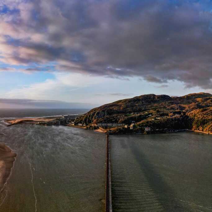
Barmouth sits at the mouth of the Mawddach like a fan opened out between cliffs and sea. You arrive along a road that squeezes between rock and water, then everything widens. The beach is long and bright, a deep arc of sand backed by houses and guesthouses with peeling paint and fresh coats sitting side by side. The old railway bridge strides across the estuary, a long run of timber and steel that begs to be walked when the weather is fair.
In town, narrow streets climb steeply behind the seafront. Stone steps, tucked cottages and little viewpoints reward curiosity with sudden views over roofs and water. The mix is part traditional seaside, part working harbour, part edge of the mountains. You can eat chips on the prom, watch the clouds race over Cadair Idris, then walk the bridge and feel the river sliding under your feet. Barmouth is busy in season, but the scale of the estuary keeps it feeling big and open.
Shell Island is less about buildings and more about the feeling of being surrounded by sky and water. You reach it via a causeway that floods at high tide, which immediately gives you that slight thrill of timing and separation. Once on the peninsula you find a rough patchwork of dunes, grass and shoreline that feels loose and spacious rather than manicured.
Walk towards the sea and the dunes lift and fall under your feet. In some places you find wide sand with mountains lining the far horizon. In others you drop into small bays and rock pools where the detail is all shells, crabs and seaweed. It is a place made for wandering and campfires rather than neat lists of sights. The wind, the tides and the quality of the light do most of the work. Shell Island is where you let the structure of your journey relax and simply live beside the sea for a while.
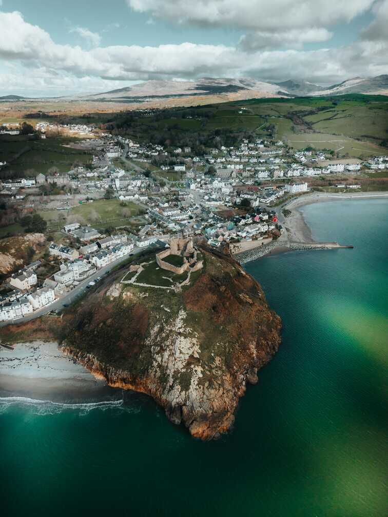
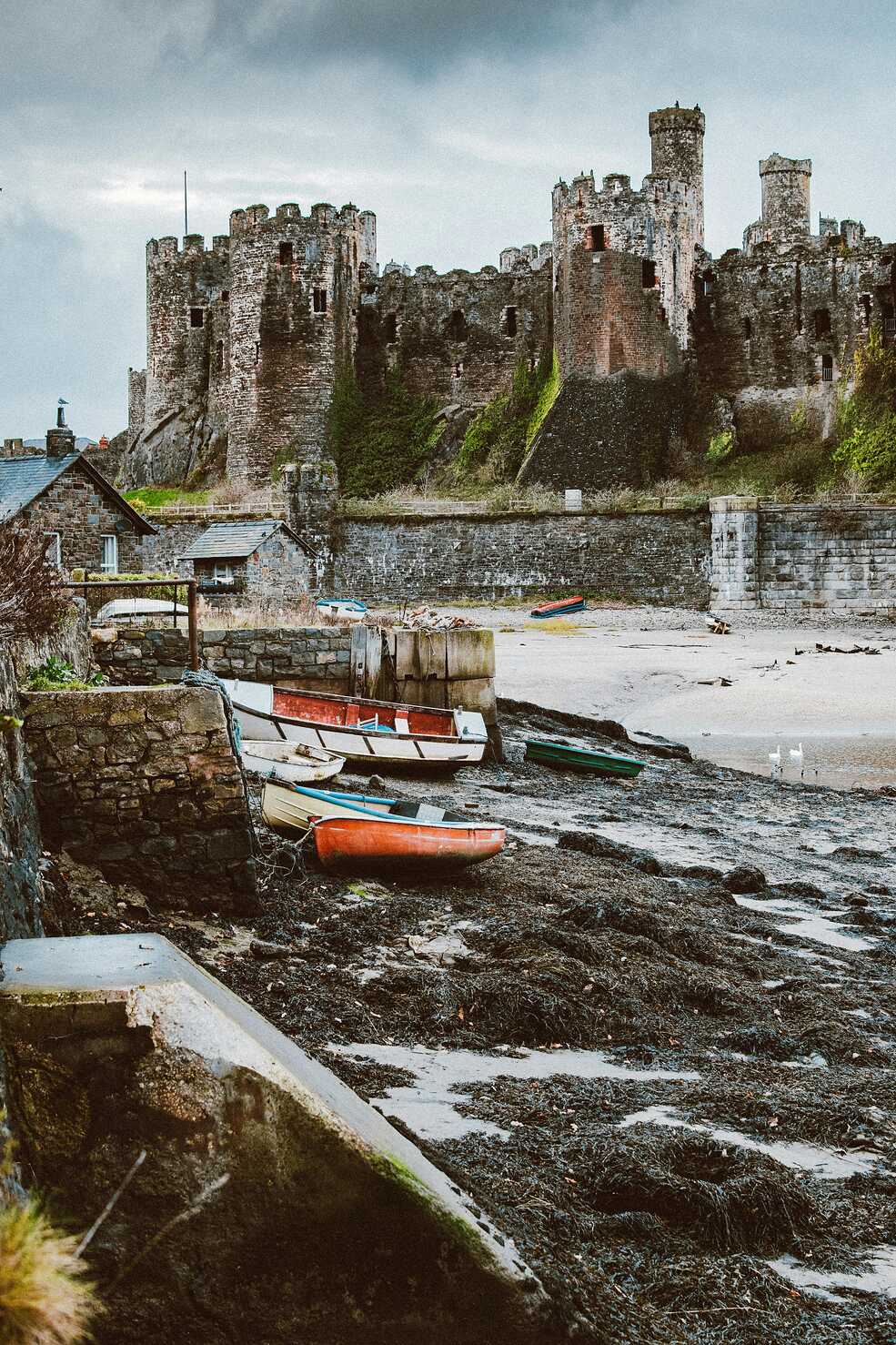
Harlech is all about height and line of sight. You drive up through the houses and suddenly the castle is there, planted on its rocky knuckle, looking out over miles of sand and sea. Even after centuries of change it still feels like a statement. Stone walls and towers stand firm against the sky, and inside you find staircases, battlements and views that make it clear why someone chose this spot to watch the coast.
Down below, the beach runs in a long straight line, backed by dunes and the distant outline of the Llŷn peninsula. You can move between castle and shore in a short time, feeling how different the view is at each level. In town, a handful of streets wrap around the base of the rock, with cafés, shops and houses following the contours. Harlech holds history and holiday in one compact package. You can climb, look, imagine sieges, then walk barefoot on wet sand ten minutes later.
Blaenau Ffestiniog sits in a bowl of mountains carved and coloured by slate. As you approach, the landscape shifts from green slopes to grey scars, terraces and tips. The town crouches in the middle of it all, rows of houses climbing the sides of the valley, the whole scene edged by dark ridges. It feels more industrial than any place you have passed so far, but that is part of the fascination.
Look closely and you see how nature is slowly knitting the scars back together. Grass, heather and trees creep between heaps of broken stone. Old inclines and tunnels now carry tours, riders and underground adventures rather than heavy wagons. Blaenau is not pretty in a classical sense, but it is compelling. You feel the weight of work that once defined it and the way it has reinvented itself without sanding off all the edges. It brings a sharper texture to your journey and reminds you how much of this national park has been shaped by human hands as well as ice and rain.
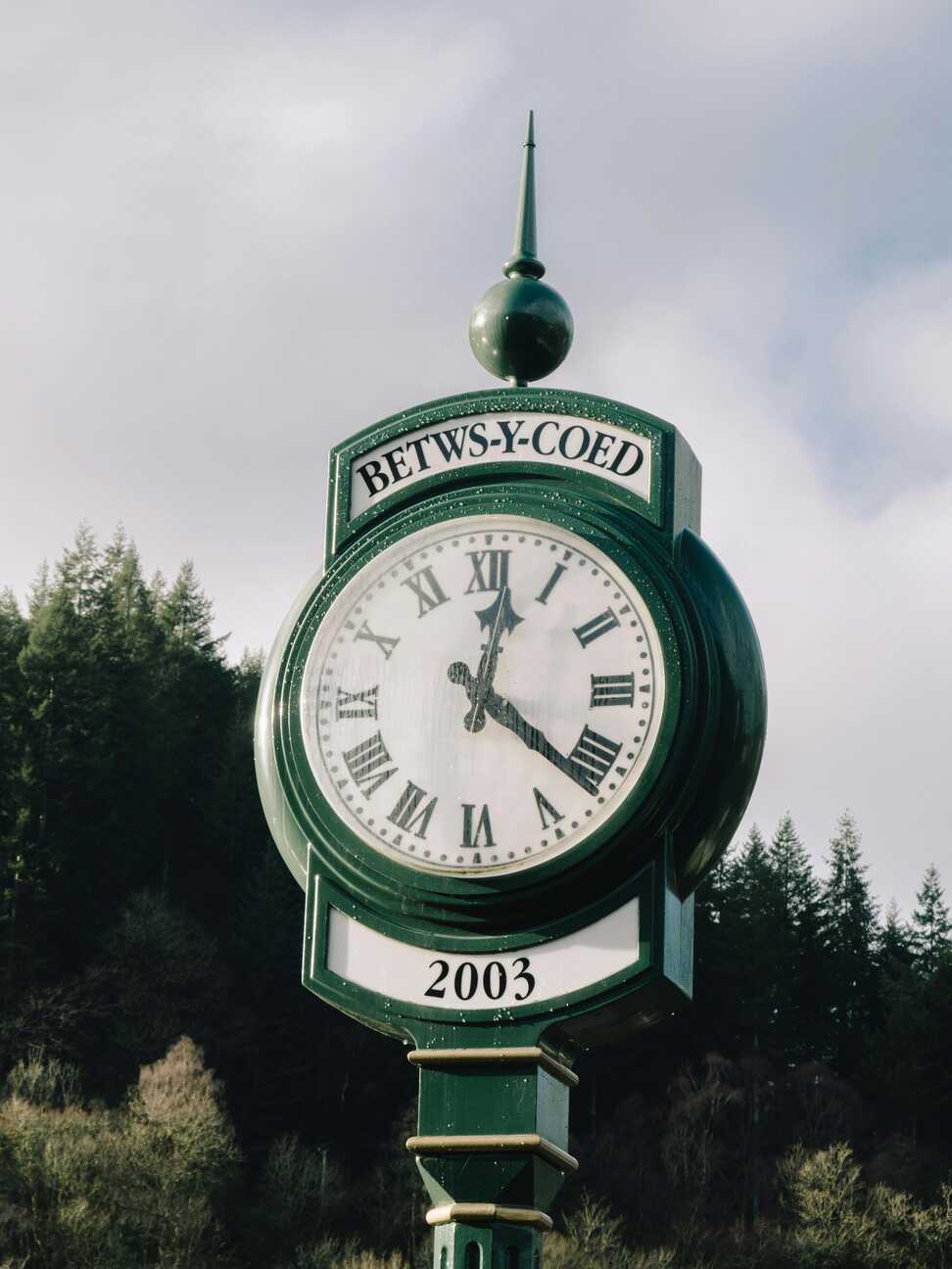
Betws y Coed feels like the classic Eryri crossroads town, held together by rivers, bridges and trees. You arrive over stone arches and the sound of water is everywhere, from the rapids of the Llugwy to the quieter pools of the Conwy nearby. The village tucks itself around this meeting of currents with hotels, cafés, outdoor shops and guesthouses all facing towards the water and the roads that feed the mountains.
Walk a short distance and you find waterfalls, moss covered rocks and forest paths that swallow the noise of traffic in a few steps. Pont y Pair bridge gives you the perfect vantage point for foaming water and tumbling boulders. Betws y Coed can be busy, but it earns that attention. It is a place where you can buy a new pair of boots, step straight into woodland and feel like the hills are waiting patiently in every direction.
Capel Curig sits high, with mountains closing in from several sides and lakes reflecting whatever the sky is doing. The village itself is small, a cluster of inns, houses and a few outdoor centres gathered along the roadside. What you really notice here is the space around it. To one side the twin peaks of Tryfan and the Glyderau rear up. To the other the broad shoulders of the Snowdon horseshoe line the horizon.
Llyn Mymbyr lies just below, long and narrow, catching perfect mirrored views of the ridges on calm evenings. Paths and tracks peel off in all directions, from short lake loops to serious summit days. Sit outside one of the cafés or pubs and you are surrounded by people in boots and waterproofs, maps on tables, dogs under chairs. Capel Curig feels like a base camp scattered along a road, full of anticipation and tired satisfaction, with the weather always a major character in the story.
Beddgelert sits at the meeting of two rivers in a tight, green valley. Stone cottages and inns lean towards narrow bridges, and the sound of water folding over rocks never really leaves your ears. The village manages to feel both carefully looked after and genuinely lived in, with flower boxes and signposts sharing space with washing lines and working chimneys.
Riverside paths lead you gently out of the centre, under trees and past occasional grazing fields. The walk to Gelert’s grave adds a layer of legend, a quiet monument in a bend of the river that ties the landscape to one of Wales’s most famous stories. Hills rise close on all sides, so you always have a sense of being held in a bowl of green and crag. Beddgelert makes a perfect pause between harder driving days, a place to slow down, eat well and fall asleep to the sound of water outside your window.
The unnamed road into Portmeirion feels like a slow reveal. You wind through ordinary woodland and glimpses of estuary, wondering where exactly this odd little place is hiding. Then, around a bend, colours start to appear between trees and you catch your first sight of towers, domes and terraces that look as if they have wandered in from the Mediterranean. The sense of stepping out of one world and into another begins before you have even parked.
There are lay bys and viewpoints where you can pause and look out over the Dwyryd estuary without committing to a full visit. From these vantage points you see the village as part of a larger scene, perched on its wooded promontory above shining mudflats and shifting channels. It is a reminder that Portmeirion’s strangeness sits inside a very natural, tidal setting. The approach road makes that contrast clear and adds a little theatre to your arrival.
Portmeirion itself is like walking into a dream someone had about a seaside town in another country. You pass through the entrance and find yourself among bright facades, archways, domes and balconies, all arranged on terraces above the estuary. Every turn seems to offer a new composition of colours, statues and viewpoints, with glimpses of water framed by painted walls and tall trees.
You can drift through piazzas, climb steps to lookouts, then drop back into woodland walks that circle the site. The estuary below adds a constant shimmer, changing with the tide and the light. Sometimes the mudflats shine like metal, other times the channels fill and the water comes close to the village walls. It is part folly, part serious design project and entirely itself. Portmeirion is a playful, theatrical pause in a route that is otherwise shaped strongly by natural forms and older stone.
Porthmadog sits where the Glaslyn and Dwyryd estuaries meet the sea, a working harbour town wrapped around water and rail. You arrive to find a long harbour wall, moored boats and the distant outline of the Cob, the great embankment that shaped this whole coastal landscape. Warehouses, cottages and shops stand shoulder to shoulder along the quays, with the odd plume of steam from one of the heritage railways reminding you that trains still matter here.
Walk the harbour and you get changing views of mountains, sandbanks and channels. On one side, the Snowdon massif rises inland. On the other, the low peninsula of Portmeirion and the open bay stretch out under the sky. You can eat by the water, browse outdoor shops or simply watch the tides nudge boats against their moorings. Porthmadog feels like a hinge town. It connects slate quarries to ports, mountains to sea, and works smoothly as both base and brief stop.
At 7 Marine Crescent in Criccieth you are pressed right up against the edge of Cardigan Bay. The terrace runs along the seafront, and from the pavement or windows you get an unbroken sweep of sea, with the dark shape of the castle on its headland to one side and the curve of beach down below. On a still day the water lies in soft bands of blue and green. On a windy one, whitecaps chase each other across the bay.
Step outside and you can be on the pebbles in moments, listening to waves rolling stones back and forth with that slow, grinding hiss that never quite repeats. The promenade ambles away in both directions, giving you easy walking and constant views. At your back, the town rises gently with its mix of houses, cafés and shops. This address anchors you firmly in the everyday life of Criccieth while keeping the sea front and centre in your experience.
Abersoch feels like a village that has grown comfortable with being a beach and boat magnet. You arrive to see masts in the harbour, bright beach huts along the sand and a steady procession of boards, sails and paddleboards heading towards the water. The main street is lined with surf shops, cafés and bars that feel set up for long summer evenings and shoulder season weekends.
The beaches are the real draw. Soft sand, relatively sheltered water and views out to the islands make them ideal for swimming, sailing and lazy days on a towel. When the light is right, boats on their moorings seem to float in the air above their reflections. Hills behind the village give you quick viewpoints if you climb a little. Abersoch can be busy, but it also offers that simple pleasure of wandering from street to shore in minutes, ice cream in hand, sea breeze lifting the day off your shoulders.
Hell’s Mouth does not bother with subtlety. You reach it by small lanes and suddenly the land drops away to reveal a huge bay, a long dark curve of cliffs and a great sweep of sand facing straight into the Atlantic. On some days the surf rolls in consistent sets, white lines marching towards the shore. On others the waves are messy and wild, the wind cutting straight across the beach.
There is usually space here. The bay is long enough that even on busy days you can find your own pocket of sand. It feels less like a family paddling spot and more like a place to walk, watch weather and feel the weight of the ocean. The name suits the mood. In poor weather you understand at once why sailors feared this stretch. In calmer conditions you can sit in the dunes and listen to the low constant roar that never quite drops to silence.
Aberdaron feels like the end of a peninsula in every sense. The village pools around a small bay, cottages, café fronts and a church gathered at the back of the beach while the road simply stops. Beyond lie Bardsey Island and open water. Behind, the land rises into the soft, rounded hills of the Llŷn. It is easy to see why this has been a place of departure and pilgrimage for centuries.
The beach is compact but lovely, a mix of sand and small stones framed by low cliffs. At high tide the sea comes almost to the wall. At low tide it opens into a broad, damp sheet of sand that reflects every shift in the sky. Sit outside with a drink or walk to the headlands on either side and you feel the village as a small, warm pocket in a much larger coastal drama. Aberdaron is a natural pause, a place where you cannot help but think about edges and crossings.
Dinas Dinlle lines itself up neatly along a long, straight beach with big views across the bay. You drive past small houses, cafés and car parks and the sea is right there, backed by a bank of shingle and low grassy dunes. On clear days you can see over to the hills of the Llŷn and along the coast towards the bulk of Yr Eifl and further into the distance.
The beach itself is a mix of sand and stones, with the tide pulling back to reveal wide flats that glint in the light. A low hill at one end holds the remains of an Iron Age fort and gives you a natural viewpoint. Climb it and you get a broad sweep of sea, fields and, inland, the distant tops of Eryri. Dinas Dinlle feels simple and unforced, a place for walks, kite flying and watching the horizon change colour through the day.
Y Felinheli sits snugly on the Menai Strait, its houses and marina tucked between wooded slopes and tidal water. You arrive along a road that dips and curves, then suddenly you are beside moored yachts and old quays, with the opposite shore of Anglesey sitting low across the channel. The water here feels more like a river than the open sea, always moving but rarely loud.
Walk the waterfront and you weave between old stone buildings and newer apartments, slipping onto paths that trace the edge of the strait. Boats come and go with the tide, and on calm evenings the surface becomes a sheet of silver that reflects every light. Behind the front, narrow streets and steps climb towards the higher part of the village. Y Felinheli feels like a halfway place, neither full city nor rural hamlet, and that makes it a gentle pause between bigger names along the strait.
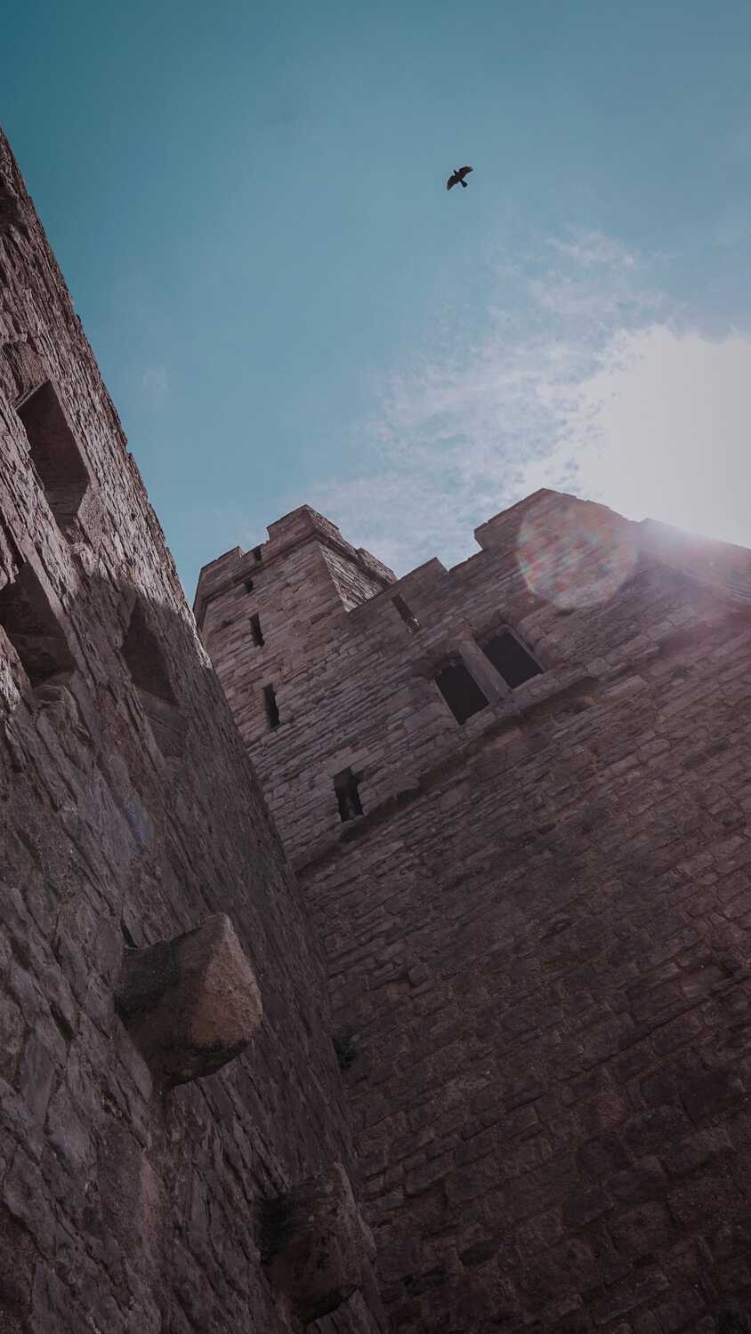
Caernarfon Castle dominates everything around it. You approach through the town and then suddenly the walls and polygonal towers rise ahead, heavy stone stacked and banded above the harbour. It feels imposing even if you know your history only loosely. The sheer scale and solidity of it make an immediate impact.
Inside, staircases wind up into towers, walls run in long lines around courtyards and gaps in the stone frame views of the Menai Strait, Anglesey and the town below. The sense of engineered power is strong. Outside, the castle walls drop almost directly to the quays, where boats and seabirds share the same busy space. Pubs, shops and houses lean against the outer edges, their colours and modern signs making a sharp contrast with the grey stone. A stop here ties together much of what this route has been about: water, mountains and centuries of people trying to control both.
Llanberis lies at the foot of high cliffs beside a long lake, a linear village stretched along the shore with Yr Wyddfa rising behind. When you arrive you feel the shape of the land at once. On one side, Llyn Padarn runs in a straight, glinting line. On the other, steep, scarred slopes climb sharply towards the high ridges of Eryri. The road and houses occupy the narrow space between.
The village is full of signs of mountain life. Outdoor shops, cafés, the Snowdon Mountain Railway station and old slate buildings turned into museums all sit close together. Paths radiate out towards quarries, viewpoints and higher routes. You can take a boat trip on the lake, walk through the old slate quarry hospitals or simply watch cloud shadows chase across the rock faces. Llanberis feels like living in the front row of a mountain theatre. You are always aware of height and weather, even while you sip a coffee on the pavement.
On a second pass through Llanberis you might focus more on the quieter details. Early or late in the day, when day visitors thin out, the lakeside path feels almost private. You can stand at the water’s edge and watch mist lift off the surface or see the last sunlight burn on the cliffs above while the village drops into shadow. The reflections of boats, trees and mountains on a still surface give the place a calmer, more reflective character.
Away from the main street, tiny lanes and footpaths cut between houses and gardens, leading to small chapels, hidden viewpoints and fragments of older buildings. The quarry tips and inclines above take on different moods with different light, shifting from harsh piles of waste rock to almost sculptural forms. Taking time for a second look lets Llanberis move from simple base for a walk up Yr Wyddfa to a place with its own layered personality.
Returning to Capel Curig later in the route, you see how its light and mood shift through the day. Morning brings clear, sharp air and peaks etched strongly against the sky. By afternoon, cloud often drifts in, softening edges and pouring through passes in slow motions that are almost as interesting as the views on clear days.
You might park by Llyn Mymbyr and just watch for a while. Reflections of the Snowdon horseshoe appear, blur and fade as the breeze rises and falls. Traffic on the road comes in pulses, then the valley falls quiet again. It is a good place to check your bearings, watch the weather and feel the pulse of the mountains without having to climb them every time. Capel Curig rewards lingering as much as it does setting off.
Bangor Pier is a long, elegant finger pointing into the Menai Strait. You step onto its wooden boards and feel civilisation fall away a little with each pace. Small pavilions, railings and lamps line the way, giving it a faintly Victorian air that suits the slow rhythm of people strolling up and down. To either side, the water shifts colour with the sky, from steely grey to bright, moving blue.
At the far end you can look back to the hills of Eryri and over to Anglesey. Boats slide past underneath, their engines a low hum. On a calm day it feels almost like hanging in the air. On a windy one you lean into the gusts and taste salt on your lips. Bangor itself sits quietly behind the pier, a mix of university buildings, shops and houses. Out here on the planks, you mostly hear feet, gulls and the rattle of rigging from any yacht that happens to be passing.
Beaumaris Castle is low and broad rather than tall, a nearly perfect concentric square of walls and towers sitting in a flat field by the Menai Strait. From outside it looks solid and compact, the moat and short green grass making it almost neat. Once inside, the complexity reveals itself. Passages run within the thickness of the walls, stairs twist to wall walks and corners open onto views of water and mountains.
The village of Beaumaris wraps around it, rows of pastel houses and Georgian fronts lining the seafront, with the castle as a stone anchor at one end. The pier reaches out into the strait, boats swing on their moorings and the opposite shore rises in a folded line of hills. It is a gentle setting for a fortress that was never quite finished. Here, the geometry of the walls, the soft light on the water and the calm streets all blend into one slow, pleasing rhythm.
Benllech offers one of Anglesey’s classic easy access beaches. You drive through the village and the road drops towards a wide sweep of sand that opens out handsomely at low tide. Cliffs and headlands bracket the bay, while behind the shore a cluster of cafés, shelters and small arcades remind you that this is a holiday spot as well as a local walking favourite.
On sunny days families spread out across the firm sand, building, paddling and swimming in shallow water that often feels a shade gentler than the open coast. On quieter days you can walk long, simple lines along the tide mark, with room to think and very little to distract you beyond the changing pattern of waves. Paths on the cliffs give you higher views if you want them. Benllech is straightforward and cheerful, ideal when you are happy for a classic beach stop without complication.
Moelfre clings to a rocky shore, a tight cluster of cottages and streets that look straight out to sea. The small harbour curves around a slipway and a pebble cove, while offshore a scattering of islands and rocks breaks the line of the horizon. This is a place with a strong lifeboat and shipwreck story, and you feel that in the memorials and the RNLI presence.
The coastal path threads above and through the village, giving you views back to the bay and along to more open stretches. Fresh air, the clink of halyards and the call of seabirds are the main soundtrack. On days when the sea is calm the water around the rocks can look almost Mediterranean in its colour. On rougher days you see clearly why the rescue stories matter so much here. Moelfre has a straightforward charm and a very direct relationship with the sea. It makes a fine, contained stop before you drop back towards the mainland.
Conwy Castle and its walls turn the town into something that looks like an illustration from a storybook. The castle rises above the harbour, all towers and battlements, while the town walls still wrap around the streets in a near complete loop. You can walk much of their length, looking down into back gardens, rooftops and narrow lanes on one side and out to sea and hills on the other.
The harbour below is busy without being frantic. Fishing boats, small yachts and tour boats share the water against a backdrop of quayside pubs and houses. Bridges over the river, old and new, give you different approaches and different views. The town inside the walls feels compact and friendly, with independent shops, cafés and market spaces. Conwy brings together quite a lot in a small space: serious medieval architecture, working waterfront and casual, modern life all sharing the same stage.
Llandudno feels like a classic Victorian seaside town that has kept its poise. The broad promenade curves between two headlands, backed by a long run of terraces in pale colours, with the Great Orme rising steeply at one end and the Little Orme at the other. The pier reaches out into the bay, all ironwork, boards and kiosks, and walking along it gives you wide views back to the town and across the water.
Behind the frontage, the streets climb slowly, lined with hotels, guesthouses and shops that cater to both week-long stays and day trips. You can take the tram or drive up the Great Orme for big views and a sense of stepping out onto a separate plateau above the town. On a still evening, the lights along the prom reflect in the sea and the whole place feels almost theatrical. Llandudno is a fitting end to this route, a place that knows exactly what it is and offers it without strain.
This route feels like a full sweep of north and west Wales, stitched together by mountains, estuaries and island-fringed sea. You start in Machynlleth and Dolgellau, where the Dyfi and Mawddach rivers run under long bridges and into the shadow of Cadair Idris. From Barmouth, Shell Island and Harlech, the coast opens out into huge estuaries and beaches, with Snowdonia’s peaks rising behind like a stone backdrop.
Further north, you cut into the hills around Blaenau Ffestiniog, Betws-y-Coed and Capel Curig. Here the landscape tightens into slate scars, waterfalls and dark lakes. Beddgelert, Portmeirion and Porthmadog soften things again, all riverside colour and harbour light, before you drift along the Llŷn peninsula through Criccieth, Abersoch, Hell’s Mouth and Aberdaron, where the sea feels like the main character. The return loop along Dinas Dinlle, Y Felinheli, Caernarfon, Llanberis, Bangor, Beaumaris, Benllech, Moelfre, Conwy and Llandudno gives you castles, piers and headlands in quick succession. By the end, you have circled mountains, islands and two coasts, with very few dull miles in between.
At the southern end, you can ease into the route gently. In Machynlleth, explore the small market town and grab coffee at somewhere like Hermit Crab Coffee before following the road through the Dyfi valley. Around Dolgellau, walking or biking the Mawddach Trail towards Barmouth gives you estuary views with the hills on both sides. Once you reach Barmouth, you can stroll the wide beach, cross the restored railway bridge on foot and hunt out the hidden cove behind the town if the tide and conditions are right. Shell Island is for dunes, rock pools and sunset watching, while Harlech offers one of the most dramatic castle and beach combinations in the country.
Heading inland, Blaenau Ffestiniog is all about slate and trains. You can ride the Ffestiniog Railway or go underground into old quarries. Betws-y-Coed and Capel Curig are your classic Snowdonia hubs, with waterfalls, forest trails and access to higher routes if you want big days on the hill. In Beddgelert, you can follow riverside paths, visit Gelert’s grave and dip into the little streets for ice cream afterwards.
Portmeirion gives you pure whimsy – Italianate architecture, woodland walks and estuary views – before you move on to Porthmadog for harbourside strolls and maybe a ride on the Welsh Highland or Ffestiniog steam lines. The Llŷn peninsula shifts the focus back to coast: Criccieth’s castle and beach, Abersoch’s harbour and surf, Hell’s Mouth’s long, wild bay and Aberdaron’s simple, end-of-the-road feel.
On the northern sweep, paddle or beach walk at Dinas Dinlle, then explore Caernarfon’s huge castle and harbour before driving the Llanberis Pass or taking the railway up Yr Wyddfa if the weather and bookings line up. Y Felinheli, Bangor Pier and Beaumaris give you softer water’s-edge time, all piers, moorings and sea walls. Finally, Conwy and Llandudno serve up a classic finish – castle walls you can walk along, a sweeping Victorian promenade and a pier that reaches out into the bay.
You are rarely far from a good café or pub on this circuit. In Machynlleth you can start the day with proper coffee and cake at Hermit Crab Coffee or a more traditional fry-up at long standing local cafés. Dolgellau has cosy bistros and pubs, and nearby Cross Foxes on the road towards Machynlleth focuses on local, seasonal ingredients.
Barmouth is full of options, from fish and chips at places like The Mermaid to more sit down meals at restaurants such as Bistro Bermo or The Fanny Talbot. As you move inland, Betws-y-Coed has a strong café scene. Spots like Alpine Coffee Shop, Y Stablau, Olif and Ty Gwyn give you everything from homemade cakes and palm oil free lunches to Spanish style small plates and classic hotel dining.
On the Llŷn, Abersoch has become a little food hub in its own right, with places like Zinc Café Bar and Grill, The Dining Room and a spread of delis, beach cafés and pubs serving local seafood and modern Welsh dishes. Around Caernarfon, Bangor and along the Menai Strait you will find everything from simple chippies and pizza to more refined restaurants, while Llandudno at the far end has a big spread of cafés and pubs. The Cottage Loaf is a good example of the traditional side, and modern spots such as The Goat on the promenade offer a different flavour.
This loop works well whether you base yourself in a couple of hubs or move every night. Machynlleth, Dolgellau and Barmouth all have a mix of guesthouses, small hotels and pubs with rooms. If you prefer sandy mornings and sea air, Barmouth and Shell Island area campsites put you very close to the beach.
Inland, Betws-y-Coed and Capel Curig are classic bases for exploring Eryri (Snowdonia). You will find everything from simple bunkhouses and hostels to country inns and smarter hotels, many geared towards walkers and climbers. Beddgelert and Llanberis are quieter alternatives, each with their own cluster of B&Bs and small hotels close to rivers and lakes.
On the Llŷn, places like Criccieth, Abersoch and Aberdaron give you seafront B&Bs, holiday parks and self catering cottages. If you want to fall asleep to surf and wake up to big skies, Abersoch and Hell’s Mouth make particularly good anchors.
Towards the end of the route, Caernarfon, Bangor, Beaumaris and Llandudno give you plenty of choice again. Caernarfon mixes townhouses and harbour view hotels under the castle walls. Beaumaris has older inns and boutique places facing the Menai Strait. Llandudno has the broadest range of all, from grand promenade hotels and Victorian guesthouses to small apartments tucked in side streets. You can finish with whatever suits you best, whether that is a quiet room above a pub or a balcony looking out over the bay.
TopStops is built to be used like a shared guidebook, not a strict itinerary.
Browse the routes to see how others have travelled an area, check the map for regularly recommended stops, and get a feel for the journey with photos, highlights, and quick info on each place. When you’re ready, follow the route yourself or adapt it to your own trip.
If you discover a spot we’ve missed, submit it. The best community suggestions get added to the map, so every route slowly improves with real travellers’ input.
Do you know somewhere we should feature in our route? Message us and we’ll get it added.

